Nationwide
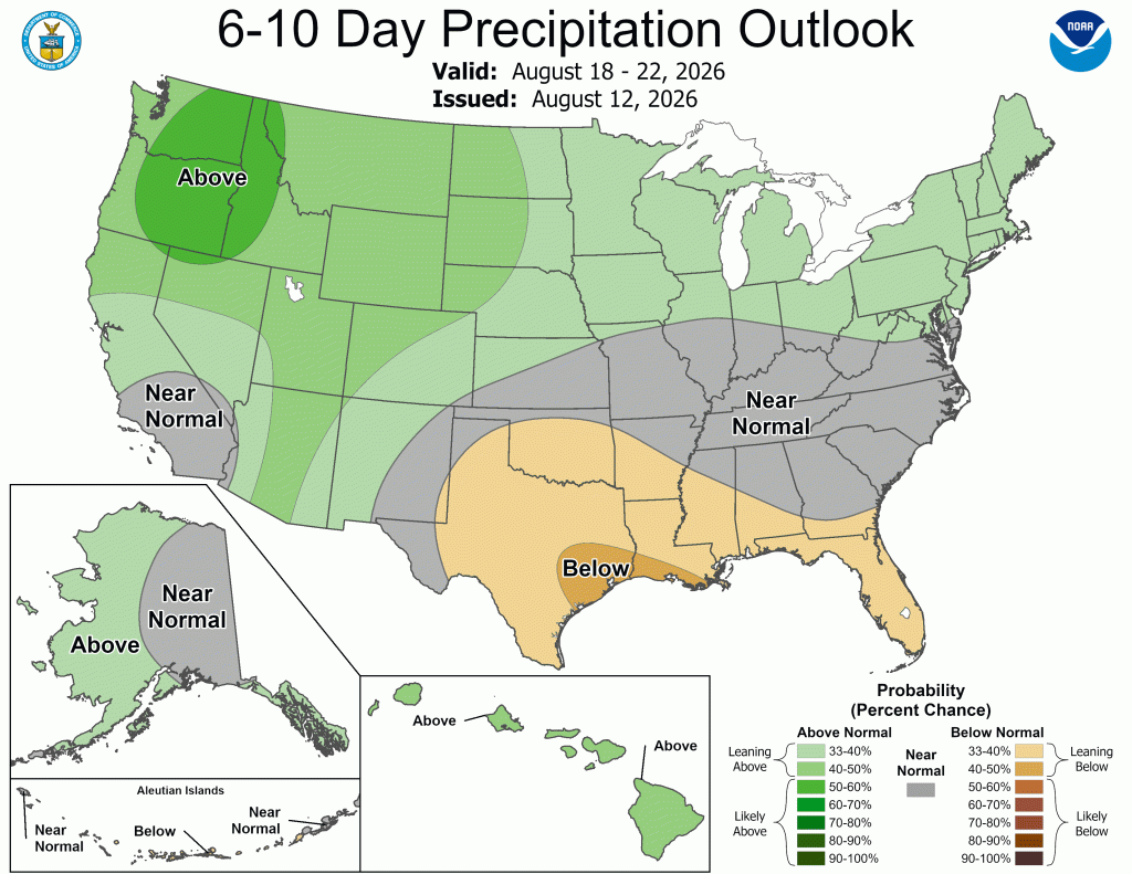
Rainfall was highly variable across the Nation this past week. Totals exceeding 2 inches were widespread from northern and eastern Indiana through much of Ohio and into West Virginia and western Pennsylvania. Localized areas across central and eastern Indiana, central and southeastern Ohio, and western West Virginia recorded 5-7 inches. Interior sections of central and northern Missouri also saw widespread totals topping 2 inches, with a few isolated patches receiving 4-5 inches. Other areas with more scattered totals over 2 inches include the Upper Midwest, east-central Great Plains, the southern Great Lakes region, the central and southern Appalachians and adjacent foothills, the Carolinas, central and northern Georgia, and the Florida Peninsula. 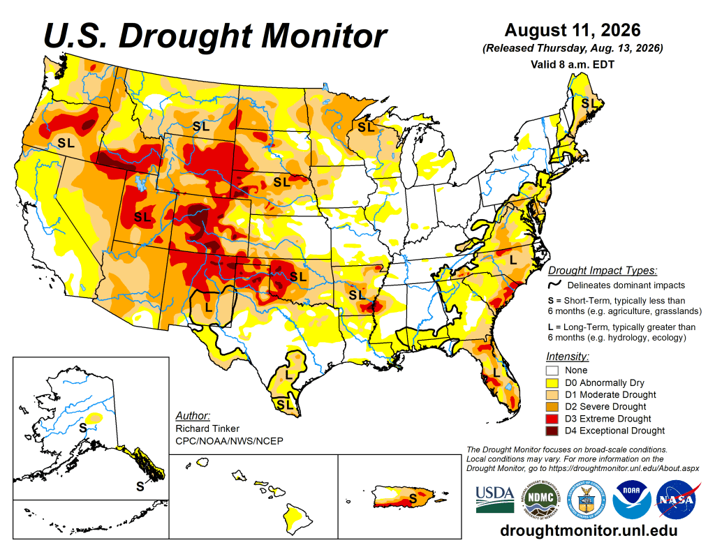
More moderate amounts, with isolated spots recording 2-3 inches, were dotted across the remainder of the Eastern Seaboard, Gulf Coast, Lower Mississippi Valley, and the Desert Southwest where a decent monsoonal circulation remained in place. Meanwhile, little or no precipitation fell on most locations in the seasonably-dry Far West, the Great Basin, the Intermountain West, much of the central and northern Rockies, most of the Plains, the Upper Mississippi Valley, the Great Lakes region, most of the Tennessee and Lower Ohio Valleys, portions of southern New England, the Virginia Tidewater, and adjacent locations. Farther north, a few tenths of an inch of precipitation was observed in central Alaska and the upper half of Southeast Alaska while little or no precipitation fell farther south there. The areas of Hawaii experiencing abnormal dryness (D0) recorded isolated amounts approaching an inch last week, but most of these areas received a few tenths of an inch at best.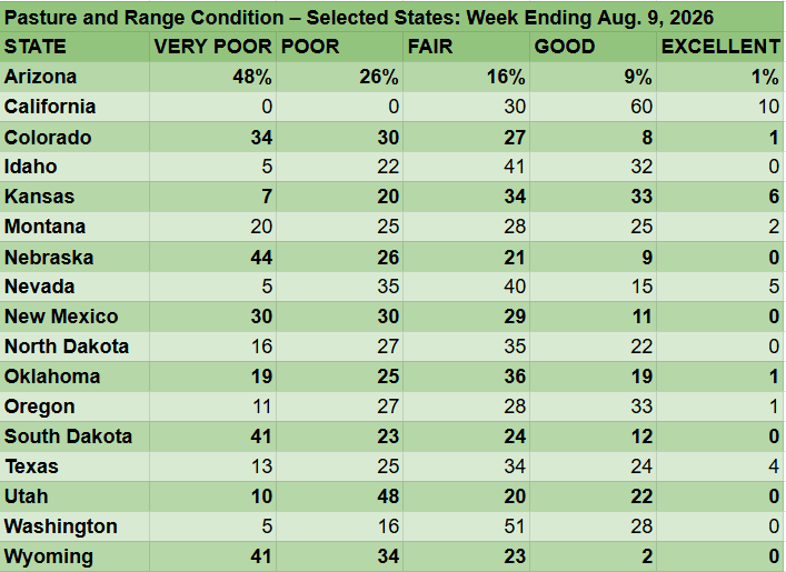
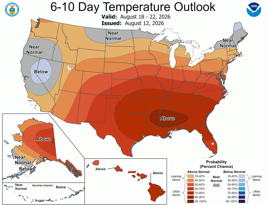
Temperatures averaged at least slightly above normal along the West Coast and from the Great Basin and Southwest through the southern Plains and most of the Lower Mississippi Valley. Most areas from the eastern Great Lakes, Ohio Valley, and Mid-Atlantic regions northeastward to the Atlantic Ocean and Canadian Border also experienced a warmer-than-normal week. Numerous locations from near the Great Basin through Oklahoma and western Texas averaged 6-10 degrees above normal, as did much of New England. Meanwhile, subnormal temperatures dominated the northern Plains. Other sites across the Lower-48 recorded near-normal temperatures for the week.
The West
Moderate to locally heavy precipitation (0.5 to 3 inches) fell on much of Arizona and New Mexico primarily due to monsoonal convection.
Farther north, a few tenths of an inch, with isolated higher amounts of over an inch, were recorded across Utah, much of the Great Basin, and some adjacent areas. The rest of the West Region was dry, with only isolated locations reporting as much as 0.2 inch. These conditions brought little change to dryness and drought across the West Region, with changes restricted to several areas of deterioration across the plains of Montana and part of the adjacent northern Rockies, similar to conditions farther east across the northern tier of the central Lower-48. Dryness and drought continue to cover a large proportion of the West Region, sparing only parts of central and western California, coastal areas near the Oregon/Washington border, and west-central Montana.
Extreme to exceptional drought (D3-D4) is common across a large swath in interior Oregon, southern Idaho, the adjacent Great Basin, and a large section of Utah. Conditions have been exacerbated by 30-day temperatures averaging 4-8 degrees above normal across Utah, southeastern Idaho, much of southern Montana, and scattered locations across the Southwest. In Utah, 33% of winter wheat is in poor or very poor condition, compared to a 5-year average near zero. In addition, one-half to three-quarters of rangelands in Arizona, New Mexico, and Utah are in poor or very poor condition, which is well above average for this time of year. In addition, multiple years of persistently below-normal precipitation have left some large reservoirs in the West with extremely low water stores. The contents of Lake Mead have dropped to an all-time low since daily reports are available, back to 1937. By August 10, the amount of stored water dropped below 7 million acre-feet (capacity is over 28 million acre-feet).
The High Plains
Moderate to heavy rainfall doused portions of eastern Kansas and adjacent Nebraska, leading to some limited relief, but totals were considerably lower elsewhere. Over 0.5 inch with isolated heavy amounts were observed in southern North Dakota, western and southern South Dakota, numerous patches across Nebraska, south-central and west-central Kansas, and the higher elevations of Colorado. 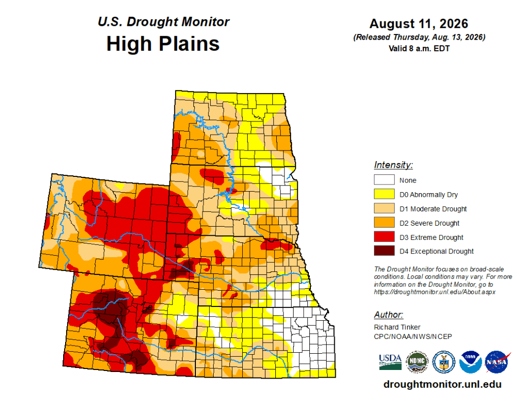
Other locations measured a few tenths of an inch, if any. Improvements were restricted to small sections of north-central and southeastern Nebraska while dryness and drought persisted or intensified elsewhere. Areas from south-central through northeastern Colorado, southernmost and northwestern through north-central Kansas, northeastern Nebraska, and the northern half of the Dakotas saw the most widespread deteriorations. Over the past 30 days, most locations outside the highest elevations of Wyoming and Colorado have recorded well below normal precipitation, with less than 25% of normal amounts recorded over central and southwestern Kansas and much of North Dakota.
There are a few stripes in the Great Plains with near- or above-normal 30-day totals, but these conditions cover much smaller areas than those experiencing dryness and drought. Currently, large sections of Colorado and Wyoming are enduring severe to exceptional drought (D2 through D4), with the worst conditions affecting significant portions of Colorado and a few patches in western Nebraska. In the Great Plains, severe (D2) or extreme (D3) drought also extends across much of Nebraska and some adjacent locales, the central and western Dakotas, and a few patches in southeastern South Dakota and southwestern Kansas.
The dryness is impacting especially surface moisture stores, including areas of reduced streamflows and degraded crops. Not all crop damage may be the result of dryness and drought, but it is the most significant contributing factor. In Colorado, 64% of pastures and rangelands are in poor or very poor condition (5-year average 23%), along with 70% in Nebraska (5-year average 30%) and 75% in Wyoming (5-year average 38%). Several crops in Colorado have a significant proportion in poor or very poor condition, including 46% of corn (5-year average 15%) and 57% of sorghum (5-year average 8%). In North Dakota, 53% of sorghum and 40% of corn are in similar condition (5-year averages of 13% and 15%, respectively). Significantly above-normal temperatures have also prevailed during the last 30 days, with temperatures averaging generally 6-9 degrees above normal in the western Dakotas, the adjacent High Plains, central and western Colorado, and western Wyoming, with the largest departures observed in the latter region.
The South
Dryness and drought have been expanding and worsening over much of the South Region for the past few weeks. 
Rapidly deteriorating conditions have been observed across Oklahoma, the Texas Panhandle, and adjacent areas of Arkansas, but almost all states saw declining conditions this past week. Tennessee was an exception, where more widespread heavier rainfall prompted some improvement in central and eastern parts of the state, with persisting or deteriorating conditions limited to northern and western parts of the state. Farther west, deterioration was introduced through most of Oklahoma (especially the eastern half of the state), the Red River Valley, Much of the Texas Panhandle and northeastern Texas, western Arkansas, northern and eastern Louisiana, and scattered patches across the remainder of the Region from the Lower Mississippi Valley westward. Oklahoma has seen very little precipitation over the last 30 days, with most locations reporting less than 25% of normal. Temperatures averaging 3-7 degrees above normal mid-summer values significantly exacerbated the drying conditions across much of Oklahoma and northern Texas, including the Panhandle.
Temperatures averaged near or up to 3 degrees above normal elsewhere. Much more abundant rainfall prior to the past 30 days is keeping longer-responding impacts from ramping up too quickly, but some crops and streamflows are being deleteriously affected. Almost half of Texas oats and over one-third of Oklahoma soybeans are in poor or very poor condition. Across Oklahoma, 44% of pastures and rangelands are in poor or very poor condition, as are 33% of those in Arkansas. — UNL Drought Monitor