Nationwide
Active weather delivered heavy showers and locally severe thunderstorms east of the Rockies, with a few exceptions. Some of the heaviest rain, locally 4 to 8 inches or more, fell from portions of the central and southern Plains into the Ohio and Tennessee Valleys, leading to pockets of flash flooding and lowland flooding. At least five flood-related fatalities were reported in Kentucky and Tennessee. 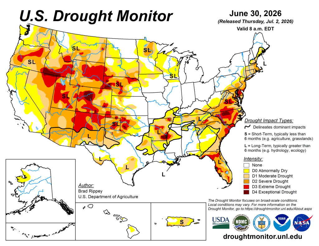
Exceptions to the wet pattern included the western Gulf Coast region, parts of the Southeast, and an area stretching from the east-central Plains into the lower Great Lakes region. At the start of the drought-monitoring period, hot, dry weather dominated the West. However, a pattern change soon brought cooler weather across the western U.S., along with widespread precipitation across the Northwest. Wet snow blanketed some high-elevation sites in the northern Rockies. During the transition from hot to cool weather, gusty winds and low humidity levels favored wildfire ignition and rapid expansion, especially in portions of the eastern Great Basin and Four Corners States. 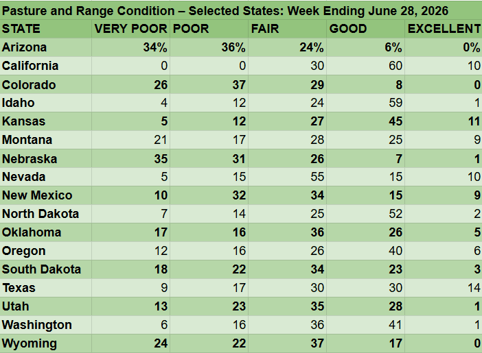
At the end of June, more than a dozen active Western wildfires had scorched more than 10,000 acres of vegetation apiece, with the largest being the 94,000-acre Cottonwood Fire near Beaver, Utah. On June 28, three federal firefighters perished in the Knowles Fire, west of Grand Junction, Colorado.
The West
During the transition from hot weather to cooler conditions, gusty winds fanned recently ignited wildfires across portions of the eastern Great Basin and the Four Corners States. 
Fire ignition and spread were also abetted by dry thunderstorms, low humidity, and near-record-to-record-setting dry fuels. Pockets of worsening drought were observed in the Four Corners States, including a notable expansion of extreme drought (D3) across the northern half of New Mexico. In the Northwest, however, heavy precipitation—including high-elevation snow—eased drought from central Idaho into western and northern Montana. Less significant precipitation fell in the Pacific Northwest.
According to the U.S. Department of Agriculture on June 28, Western States reporting rangeland and pastures rated at least one-half very poor to poor included Arizona (70%) and Colorado (63%), while states with topsoil moisture more than one-half very short to short were Colorado (89%), Wyoming (81%), Utah (69%), New Mexico (68%), Nevada (65%), and Oregon (62%).
The High Plains
As in other parts of the central and eastern U.S., a patchwork of showers provided drought relief in some areas. Some of the heaviest rain, occasionally accompanied by thunderstorm-driven high winds and large hail, fell in portions of all six states in the region. 
However, southeastern Nebraska was one area that missed all the rain. One of the most impressive outbreaks of severe weather occurred on the night of June 28-29, when a swath of wind damage stretched from northwestern Nebraska into southeastern North Dakota and beyond. An unofficial wind gust to 131 mph was clocked in Hyde County, South Dakota, while a gust to 112 mph was recorded at a mesonet station near Ree Heights in Hand County, South Dakota. Despite all the rain, the U.S. Department of Agriculture reported that rangeland and pastures continued to struggle. On June 28, statewide rangelands and pastures were rated 66% very poor in Nebraska and 63% in Colorado.
The South
The South experienced a second consecutive week of widespread reductions in drought coverage. In fact, flash flooding and lowland flooding plagued some of the hardest-hit areas, including the Arklatex and the southeastern corner of Oklahoma, where 2-week rainfall totals locally exceeded 10 inches. Much of the northern tier of the region, from Oklahoma to Tennessee, also received multiple rounds of heavy rain. 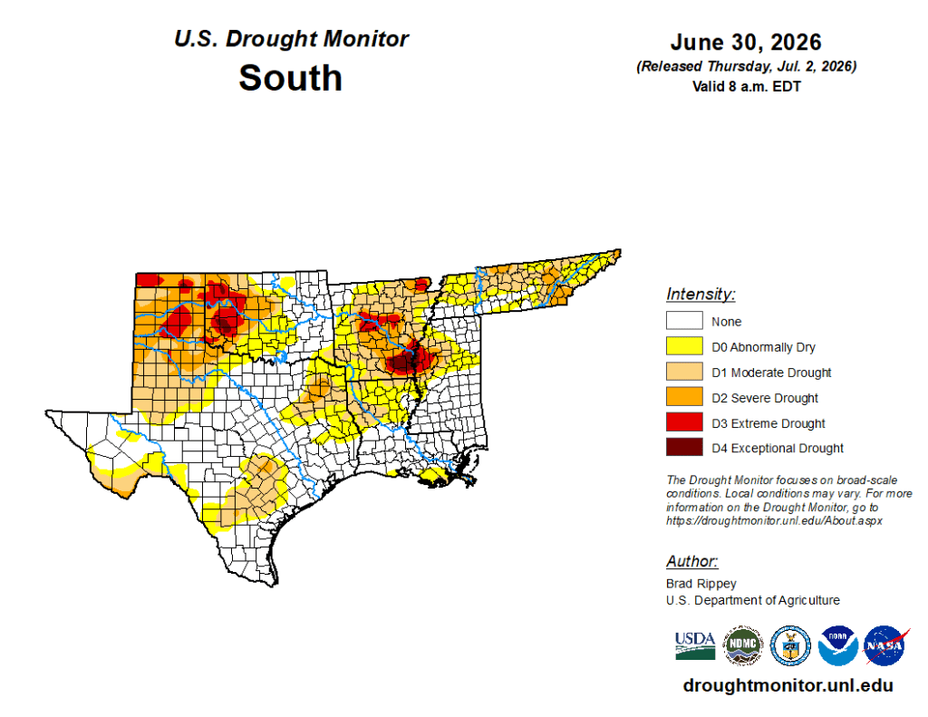
Although mostly dry weather prevailed in south-central Texas, some additional improvements were introduced, as impacts of recent downpours on long-term drought became more apparent. By June 28, the U.S. Department of Agriculture indicated that statewide topsoil moisture in agricultural regions was 28% surplus in Louisiana. — UNL Drought Monitor