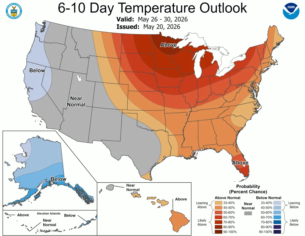
Nationwide
During the week, the contiguous United States exhibited significant regional temperature anomalies driven by a highly amplified synoptic pattern.
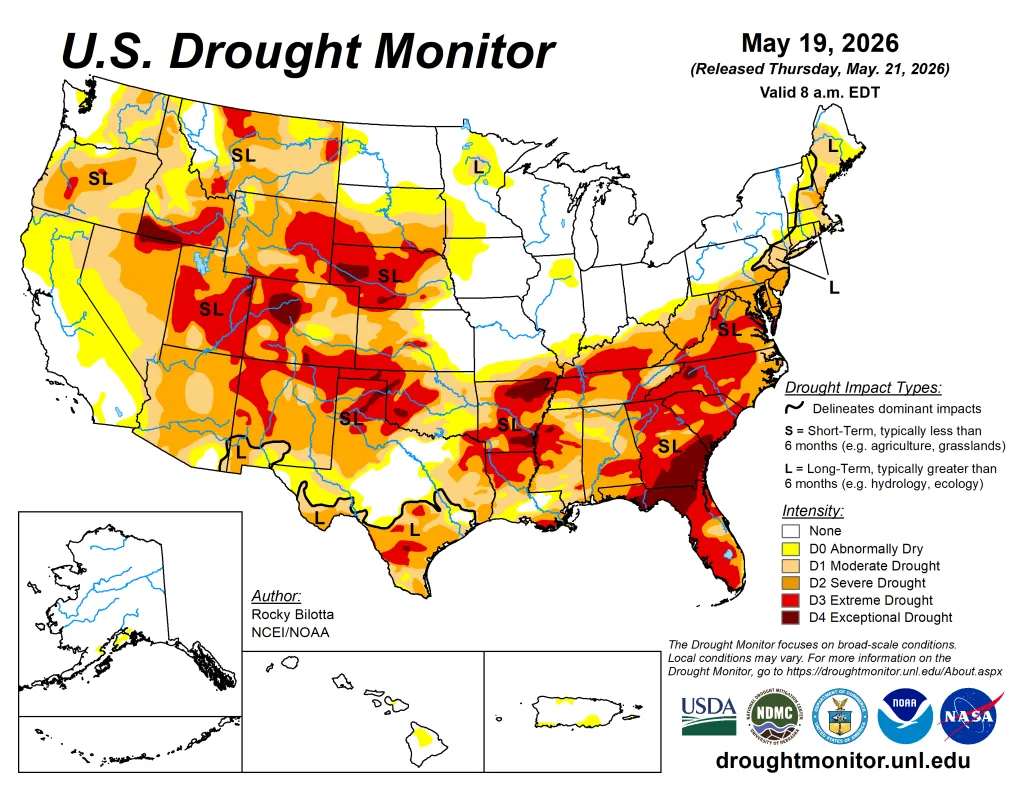
Early in the period, a pronounced unseasonable cold air mass influenced the Northern Plains, Upper Midwest, and Northeast, depressing temperatures 5-15 F below normal across the Dakotas, Minnesota, New York, and Pennsylvania. Conversely, the Southwest and South Texas experienced anomalous warmth, with maximum temperatures exceeding 90 degrees F and averaging up to 15 degrees F above normal. By the latter half of the week, this warm air mass expanded eastward into the Ohio Valley and Mid-Atlantic, initiating an early-season heatwave with observed maximum temperatures climbing into the mid-80s to low 90s.
Precipitation regimes during this period were characterized by severe convective outbreaks and pronounced moisture disparities. In the early part of the week, persistent onshore moisture transport led to heavy rainfall totals of 4 to 6 inches across the central Gulf Coast, particularly in Louisiana, Mississippi, and Alabama.

Between May 17 and 18, a powerful frontal system traversing the central United States triggered widespread severe weather across the Great Plains and Midwest. This system produced damaging winds up to 80 mph, large hail, and multiple tornadoes across South Dakota, Nebraska, Iowa, Kansas, and Missouri, alongside localized flash flooding. In contrast, extreme moisture deficits persisted west of the Rocky Mountains, where weekly precipitation totals generally remained under 0.10 inches, further elevating wildfire risk across the southern High Plains.
The West
Temperatures varied across the region this week, with average readings ranging from the mid-30s and 40s across the northern tier and high elevations to the low 80s in the desert Southwest.

In terms of departures from normal, unseasonably cold conditions dominated the northern half of the region, with departures ranging between 3 and 9 degrees below normal. In sharp contrast, the southern tier experienced unseasonable warmth. A building ridge over the Southwest drove temperatures in southern California, Arizona, and New Mexico 3-9 degrees F above normal, with eastern New Mexico seeing the greatest extremes.
Precipitation across the Western region was characterized by an extreme contrast between a highly active storm track in the Pacific Northwest and aridity across the remainder of the region. Above-normal precipitation was confined to much of Washington and parts of Oregon and Montana, where weekly rainfall totals ranged between 1.5 to 3.5 inches, with localized totals in the Cascade Range exceeding 4.5 inches. This activity generated substantial departures of 0.75 to over 3.0 inches above normal, justifying moderate (D1) to severe (D2) drought and abnormal dryness (D0) improvements in Washington and northern Idaho, and abnormal dryness (D0) improvements in northwestern Oregon and western Montana.
Conversely, dry conditions persisted across nearly the entire remaining geographic footprint. Widespread areas across California, Nevada, Arizona, New Mexico, and parts of Idaho, Montana and Utah recorded negligible rainfall totals of less than 0.10 inches. Due to the climatological onset of the dry season in parts of the West, this lack of rainfall translated into modest negative departures ranging from near-normal to 0.75 inches below seasonal averages. Nonetheless, deteriorating conditions led to the expansion of exceptional (D4) drought in southern Idaho and extreme (D3) drought in parts of New Mexico, Arizona, Utah, Montana, and southern Idaho. In addition, severe (D2) drought was expanded in Oregon, Montana, and Arizona, while moderate (D1) drought expanded in parts of Idaho, Montana, Nevada, and Arizona.
The High Plains
Temperatures were above normal across much of the region this week, with average readings ranging from the low 40s along the Canadian border and in the mountains to the mid-70s across southern Kansas.
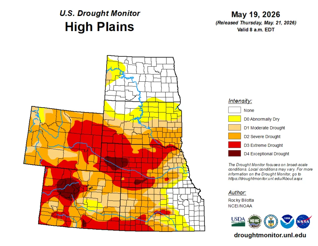
Highly anomalous early-season warmth gripped the southern half of the region. The core of this heat anomaly was centered over Kansas and Colorado, where weekly temperatures soared 6-12 degrees above historical averages, with localized spots in southern Kansas peaking more than 12 degrees above normal. This unseasonable warmth extended moderately northward into Nebraska, yielding departures of 3-6 degrees above average. Conversely, the northern High Plains remained under a more seasonal air mass; North Dakota, South Dakota, and northern Wyoming experienced below-normal conditions, fluctuating within 3-6 degrees of historical baseline temperatures.
Precipitation amounts varied across the region, with extreme dryness across much of the region and a highly concentrated deluge along the southeastern boundary. Large portions of Wyoming, Colorado, and western parts of North Dakota, South Dakota, Nebraska, and Kansas reported weekly totals below 0.50 inches, with extensive areas receiving less than 0.10 inches. This lack of moisture resulted in departures of 0.5 to 1.5 inches below average, causing conditions to deteriorate. Extreme (D3) drought expanded in southwestern Kansas and southern Colorado. Severe (D2) in parts of Colorado and northeast Wyoming, while moderate (D1) drought expanded in parts of South Dakota. In stark contrast, intense convective activity produced a sharp corridor of heavy rainfall across eastern Kansas and Nebraska. Totals in this localized zone rapidly climbed between 2.5 and 5.5 inches, with departures ranging between 1.5 to over 4.5 inches above normal, resulting in improvements to moderate (D1) to exceptional (D4) drought in Nebraska and moderate (D1) to extreme (D3) drought in Kansas. Heavy rainfall also brought improvements to severe (D2) to exceptional (D4) drought in northern Colorado and a reduction of exceptional (D4) drought in southern Wyoming this week.
The South
Below-normal precipitation dominated the South this week. The vast majority of Texas, Oklahoma, Arkansas, Louisiana, Mississippi, and Tennessee received less than 0.10 to 0.50 inches of total rainfall, leaving nearly the entire geographic footprint under exceptionally dry conditions. This lack of rainfall resulted in widespread departures of 0.75 to 1.50 inches below normal.
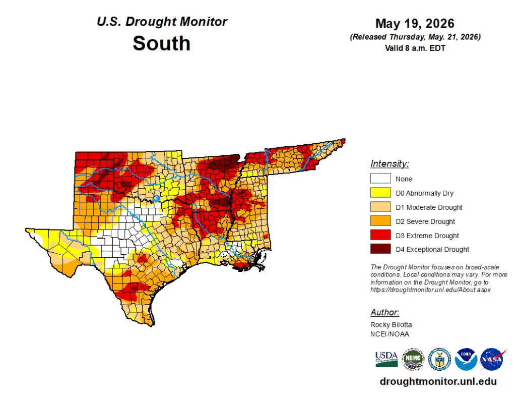
Below-normal rainfall totals led to the introduction of an exceptional (D4) drought in the Oklahoma Panhandle and to D4 expansion in parts of Arkansas and Mississippi. Extreme (D3) to severe (D2) drought was expanded in parts of Oklahoma, Arkansas, Mississippi, and Tennessee. The major exception to this dry regime was concentrated in the southern portions of the region, specifically southern Texas, where localized convective storms delivered 1.0 to 3.0 inches of rainfall, resulting in the improvement of extreme (D3) drought in southern portions of Texas, Louisiana, and Mississippi.
Temperatures were above normal across much of the region, ranging from the upper 50s and low 60s in Tennessee to the upper 80s in parts of Texas. Looking at departures from normal, a highly anomalous zone of intense warmth gripped the western half of the region, where temperatures averaged 6-15 degrees above historical norms. Conversely, the eastern tier of the region bucked the western warming trend entirely; Mississippi and Tennessee experienced unseasonably cool conditions, with temperatures suppressing to 3-6 degrees below normal. — UNL Drought Monitor