Nationwide
Heavy rain fell this week across parts of the United States, bringing widespread relief from ongoing drought and abnormal dryness from northeast Texas through the Mid-Atlantic.
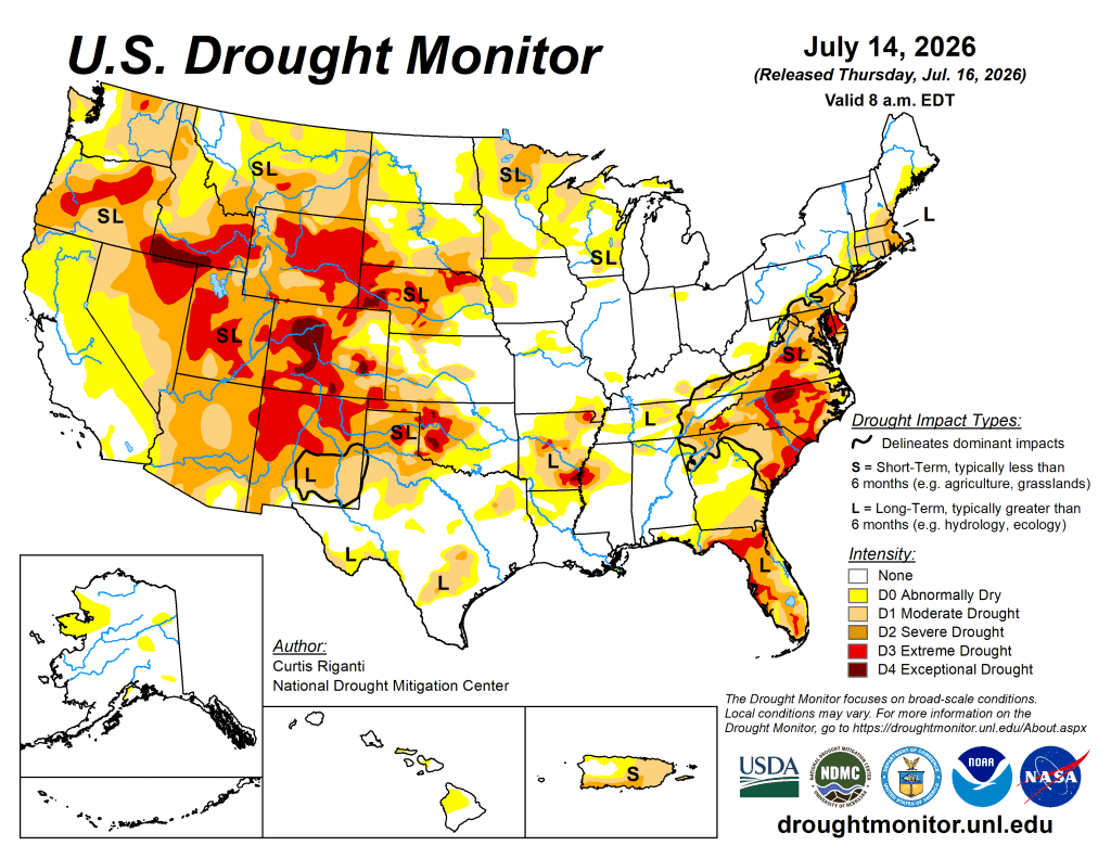
Recent rains shifted drought impacts more towards the longer term in some areas. Localized improvements after recent precipitation occurred in parts of southern New York and southern New England and in portions of the central Great Plains. Localized improvements occurred in small areas of northwest Alaska and north-central Puerto Rico after heavy rains this week. An assessment of shorter-term conditions in Utah and portions of western Oklahoma and western and southern Texas led to a few improvements.
Warm and dry weather occurred this week in the western Great Lakes, especially in far northern Wisconsin, parts of the Michigan Upper Peninsula, northern Minnesota and eastern North Dakota. These areas saw widespread degradation given this week’s conditions. Drier areas in central Colorado also saw the expansion of extreme and exceptional drought this week. Abysmal streamflow and short-term precipitation deficits persisted across parts of Washington, leading to widespread degradation. Severe drought expanded in both south-central Puerto Rico and southeast Florida owing to short-term rainfall deficits in both areas.
The West
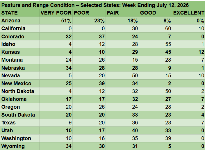
Aside from some moisture in southeast Arizona from the North American Monsoon, mostly dry weather occurred in the West this week to the west of the Continental Divide. In southeast Arizona, rains totaling 1-2 inches fell, though these were not enough to improve conditions. In southeast New Mexico, conditions were reassessed along with those in western Texas, leading to localized improvements where soil moisture, streamflow and mid-term precipitation deficits have recently improved.
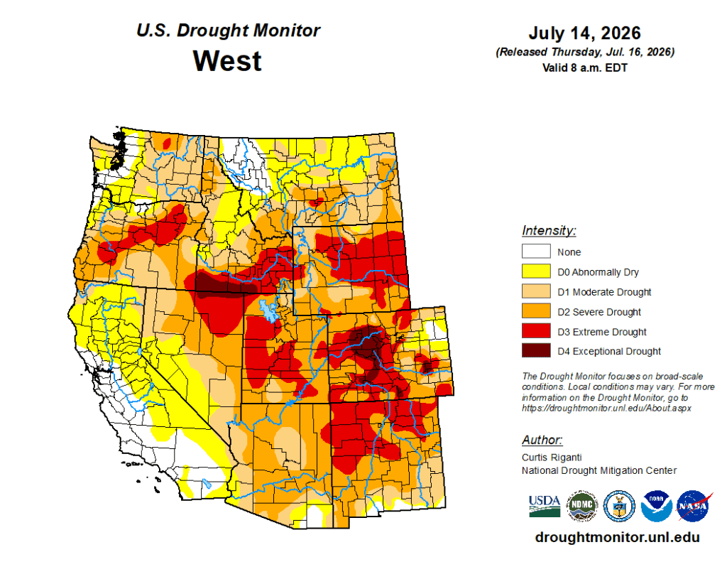
Localized improvements also occurred in parts of Utah where short-term precipitation deficits lessened. However, widespread severe and extreme drought persisted across most of the state, with low streamflow throughout Utah. In eastern Washington, short- and mid-term precipitation deficits, recent warm temperatures and poor soil moisture led to the expansion of moderate drought. Moderate and severe drought also developed or intensified across several other parts of the state, where precipitation deficits persisted and soil moisture and streamflow decreased.
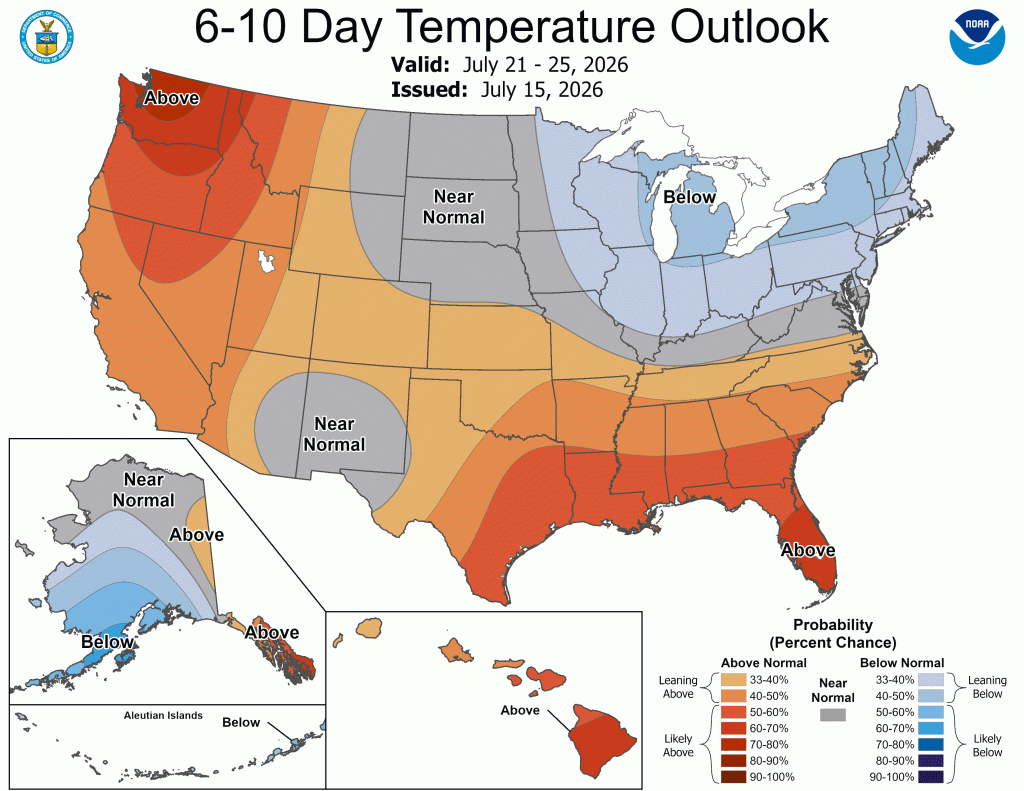
Hot temperatures occurred from Arizona and western New Mexico northward to Montana and Wyoming. Temperatures were 3-6 degrees above normal across most of these areas for the week, while northeast Wyoming and south-central and eastern Montana were 6-12 degrees warmer than normal. Several cities in southern and eastern Montana set all-time record highs on Sunday, July 12, including readings of 115 F in Miles City and 111 F in Billings. The impacts of this heat wave on ongoing drought conditions will be assessed in the coming weeks. Temperatures along the Pacific Coast were generally within 3 degrees of normal.
The High Plains
Rains exceeding 2 inches fell this week in northeast South Dakota and from parts of south-central Nebraska southeast through parts of northeast Kansas.
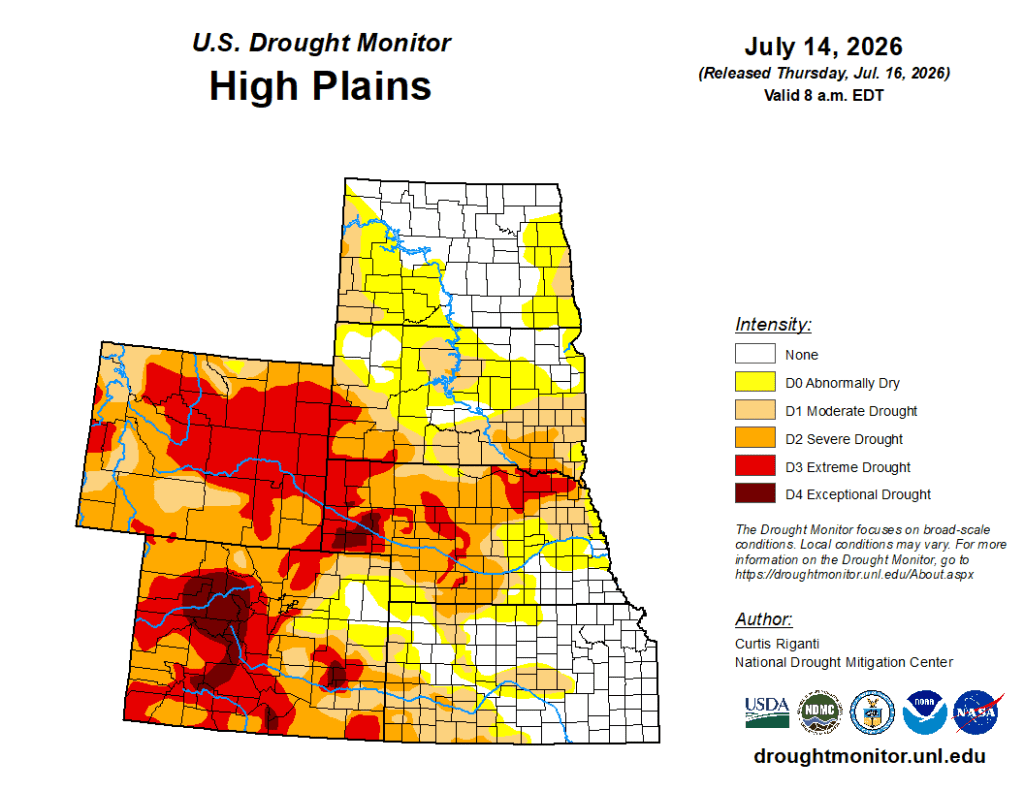
Spotty heavy rain, locally in the 1.5-2-inch range, fell across eastern Colorado, western Kansas, western Nebraska and southwest South Dakota, as well as a few areas in North Dakota. These rains led to localized improvements in eastern Colorado, western Kansas and western Nebraska, where soil moisture increased, and precipitation deficits eased. Widespread improvement to ongoing drought and abnormal dryness occurred in northeast South Dakota, where the heaviest rains fell. In eastern North Dakota, short-term precipitation deficits combined with reduced soil moisture resulted in the widespread expansion of abnormal dryness, with a small area of moderate drought. A few areas in north-central and northwest South Dakota experienced degradation, with short- and mid-term precipitation deficits and low soil moisture. Temperatures in the northern portions of the High Plains region, particularly from northwest Nebraska north, were 3-9 degrees above normal this week as a heat wave took hold. The impacts of this heat and locally drier weather will be assessed in the coming weeks.
The South
Wet weather occurred this week across much of Tennessee, portions of northern Alabama, much of south-central and western Louisiana and portions of eastern and south-central Texas. The heaviest rains exceeded 5 inches in parts of Texas and Louisiana, while 2-5 inches of rain were common in parts of Tennessee.
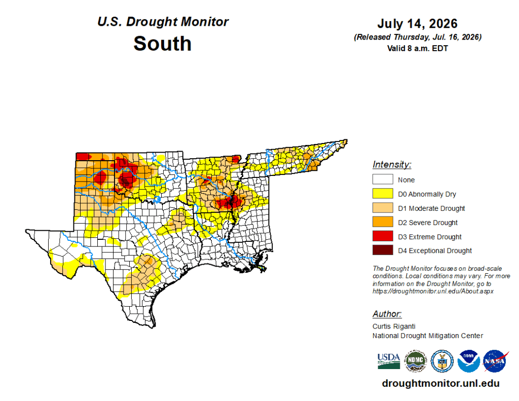
Temperatures across the region were mostly within 3 degrees of normal, except in southern Texas Panhandle and western North Texas, where temperatures were commonly 3-6 degrees warmer than normal. Temperatures from 3-6 degrees below normal occurred along the Rio Grande near Del Rio, Texas. From eastern Texas across southern Louisiana, and in Tennessee and far northeast Arkansas, this week’s rains lessened or locally eliminated precipitation deficits and led to improvements in soil moisture and streamflow. Conditions were reassessed and improved in parts of western and southwest Texas, adjacent western Oklahoma and the Oklahoma Panhandle and in parts of western and northern Arkansas, where recent precipitation has lessened mid-term precipitation deficits and locally improved streamflow and soil moisture. — UNL Drought Monitor