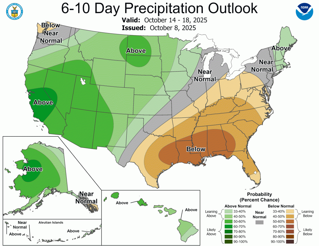
Nationwide
The recent pattern of numerous changes in the U.S. Drought Monitor (USDM) continued with this week’s map release.
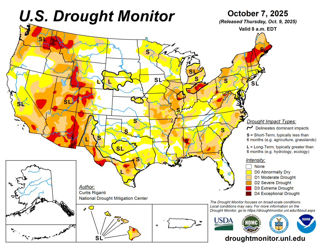
Continued dry weather in the Northeast led to widespread worsening of drought and abnormal dryness there. From Missouri northward to the Great Lakes states, many locations saw drought or abnormal dryness worsen. In particular, intense short-term drought continued to worsen in parts of Missouri, Illinois, Indiana and Ohio. However, in southeast Missouri, the Ohio River Valley, and parts of the Mississippi River Valley, welcome rains fell, locally over 3 inches, leading to widespread improvements in the ongoing drought and abnormal dryness in these areas. Much of Alabama, the Carolinas and Georgia saw drier weather, with local exceptions. As such, drought and abnormal dryness also expanded across portions of these states and a few spots in nearby Florida. Very heavy rain fell in southeast Louisiana; one area received over 5 inches of rain, leading to a 2-category improvement in the USDM, surrounded by nearby 1-category improvements after the heavy rain. In west Louisiana, Oklahoma and Texas, dry weather this week led to many degradations as primarily short-term dryness intensified. A few areas of central and southwest Texas are also seeing long-term dryness and drought and saw some intensification this week.
Drier weather this week in northeast Montana led to the development of a moderate drought there. Recent heavy precipitation and reassessment of recent conditions led to widespread improvements in parts of the western United States, especially the Las Vegas area, northern areas of Nevada and Utah, Oregon and southwest Idaho, southeast Wyoming and a few spots in the Colorado Rocky Mountains.
The West
Cooler-than-normal temperatures prevailed in much of Oregon, California and Nevada, while the rest of the region was mostly 1-5 degrees above normal. Scattered heavy precipitation fell this week across much of the central and northern half of the region, with notable exceptions in central and eastern Washington and Oregon, southwest Wyoming, and north-central and northeast Montana.
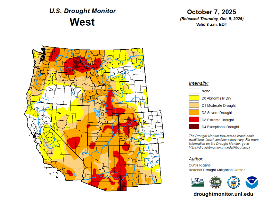
In northeast Montana, drier weather this week and temperatures 5-15 degrees above normal led to the development of moderate drought, with short-term precipitation and soil moisture deficits growing. Recent precipitation, either this week or in the weeks preceding, led to improvements in streamflow and soil moisture and to a lessening of precipitation deficits across much of northern and southern Nevada (and immediately adjacent parts of California and Arizona). Similarly, improvements in conditions also occurred in northern Utah, south-central and southwest Idaho, Oregon, and the Olympic Peninsula of Washington, leading to improvements in the USDM depiction in parts of these areas.
The High Plains
Temperatures this week across the High Plains region were mostly 5-15 degrees above normal, with parts of central Colorado and southern and western Wyoming seeing closer to normal temperatures.
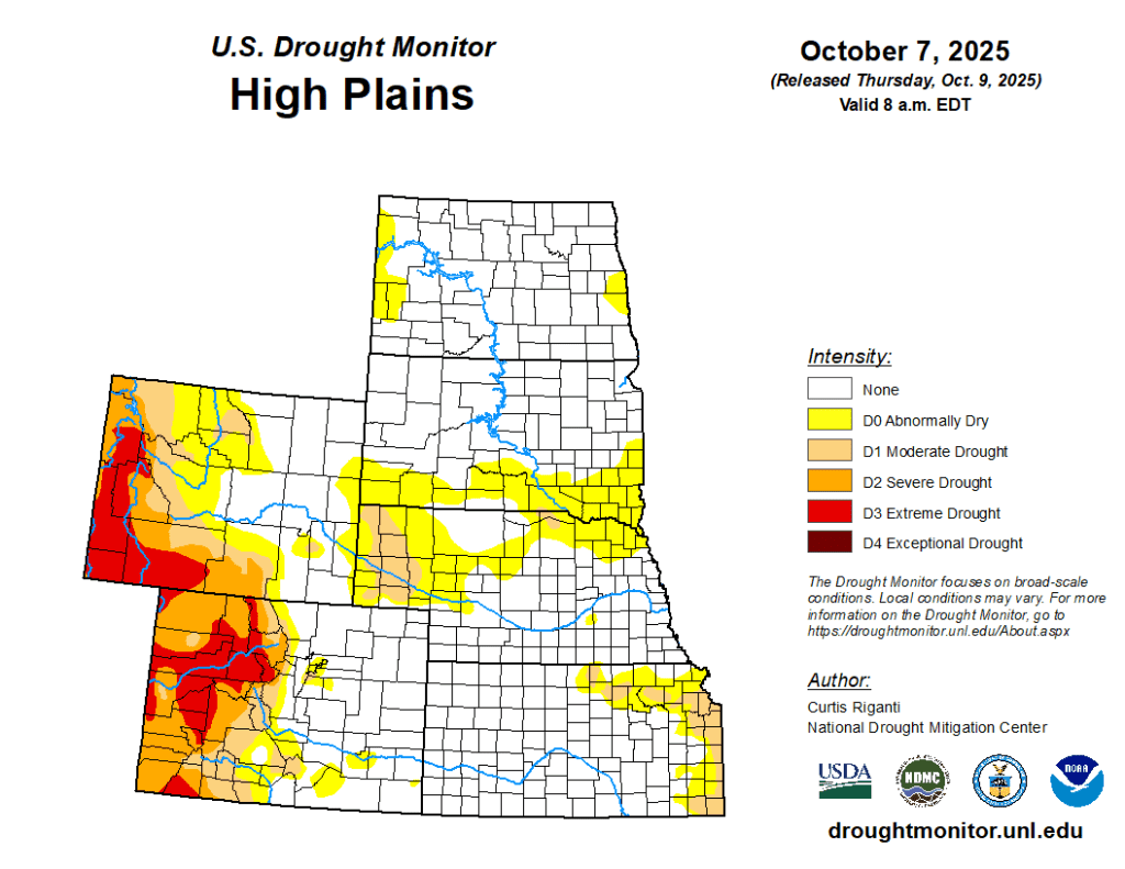
Moderate to locally heavy precipitation fell in parts of the San Juan Mountains in southwest Colorado, the Rocky Mountains of northern Colorado and across much of Wyoming, northwest South Dakota and central to north-central North Dakota. Precipitation this week added to a generally wetter recent pattern in the San Juans, north-central Colorado and southeast Wyoming. In these areas, short- and medium-term precipitation deficits lessened and soil moisture conditions improved, allowing for some improvements to the ongoing drought and abnormal dryness.
In north-central Kansas, moderate drought improved in some areas where locally over 2 inches of rain fell. In eastern Kansas, short-term abnormal dryness and moderate drought worsened in spots where streamflow and soil moisture levels dropped, along with growing precipitation shortages. In northeast Nebraska and southeast South Dakota, dry weather over the past couple of months persisted this week, leading to a large expansion of abnormal dryness that also extended into northwest Iowa and southwest Minnesota.
The South
Pockets of heavy rain, locally 3 inches or more, fell in western Tennessee and adjacent northwest Mississippi and northeast Arkansas, in southwest Mississippi and in southeast Louisiana this week.
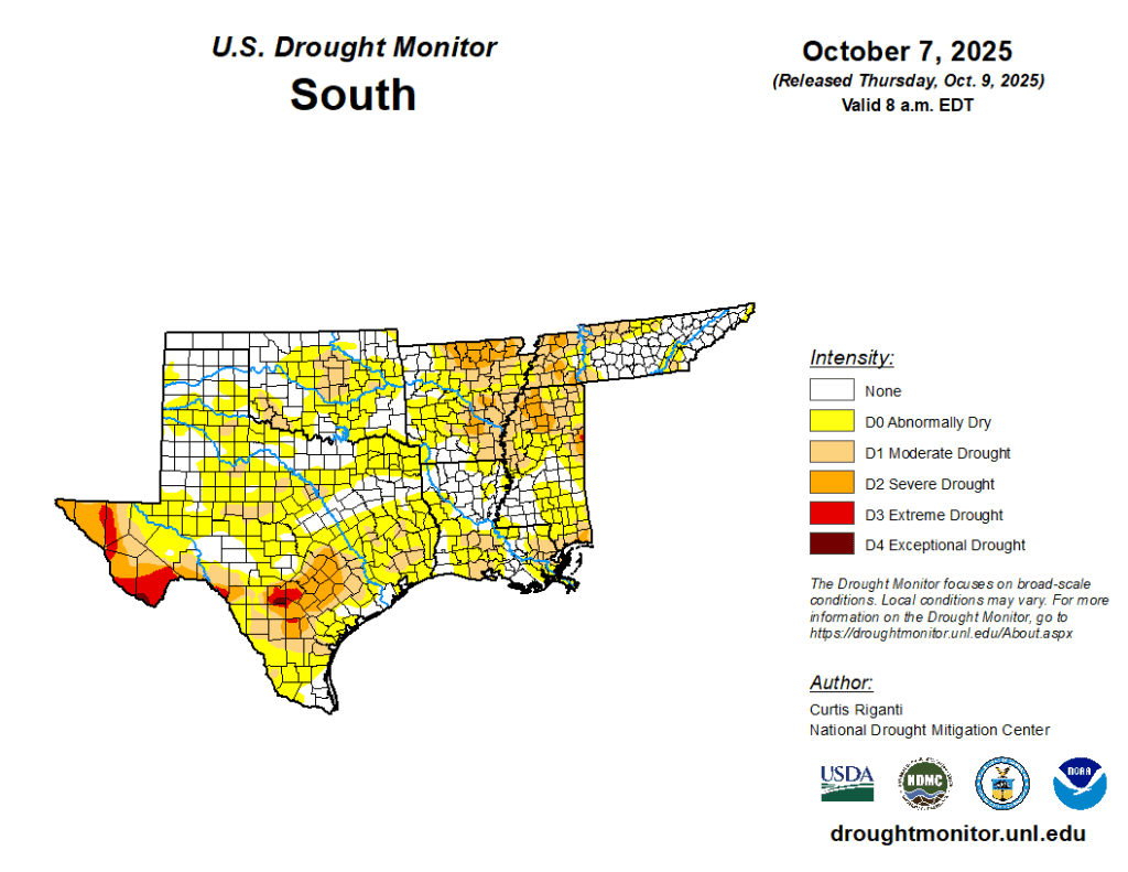
The heavy rain was enough to improve overall conditions in much of western Tennessee, northeast Arkansas and in southeast Louisiana, where a localized 2-category improvement occurred. Parts of east-central and northeast Mississippi were much drier this week, leading to an expansion of moderate, severe and extreme drought. In these areas, precipitation deficits grew and soil moisture and streamflow continued to drop. Short-term dryness continued to intensify in south-central and west-central Louisiana and across much of Texas and parts of Oklahoma, all of which largely saw a mostly dry and warmer-than-normal week. Very dry weather over the last month continued in parts of Oklahoma, especially from the Oklahoma City area north and in southwest Oklahoma, where adverse impacts to agriculture were reported. In central and southwest Texas, recent dry weather compounded the impacts of long-term drought. — UNL Drought Monitor