Record warm temperatures and below-normal precipitation have been the dominating trends since the start of the 2026 water year, on Oct. 1, 2025. The average air temperature in Colorado during October and November was the second warmest on record, dating back to 1895. These warm and dry conditions have led to a well-below normal snowpack across all major river basins in the state.
Precipitation trends across Colorado have been more variable since the start of the water year and are currently closer to normal levels than snowpack. Current streamflow forecasts for the 2026 runoff season are mostly below normal across all major river basins. Reservoir storage across the state is currently below normal and slightly lower than this same time last year. With still a few months left in the typical snow accumulation season, there’s still time for conditions to improve.
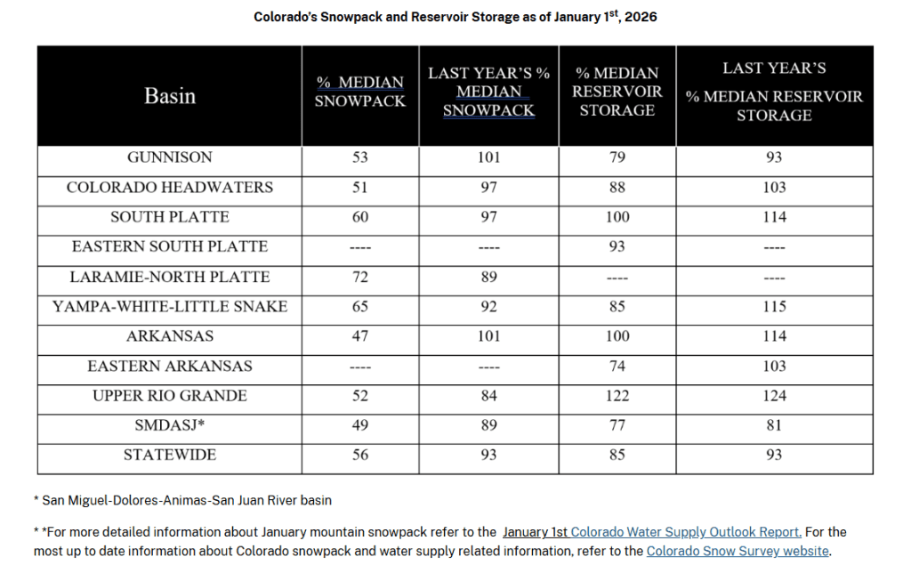
As of Jan. 1, statewide snow water equivalent (SWE) is at 56% of median, and 38% of SNOTEL sites across the state that have 20 years of historical data or more have record-low snowpack. Most of these record low SNOTEL sites are situated in the central and northern mountains where abnormally warm temperatures have been most prevalent. SWE across the state ranges from 47% of median in the Arkansas river basin to 72% of median in the combined Laramie-North Platte river basin.
Above-normal temperatures have caused a larger percentage of precipitation to fall as rain instead of snow this water year, and consequently, statewide precipitation amounts are much better than snowpack levels.
Water year-to-date precipitation for Colorado is at 89% of median and ranges from 72% of median in the Upper Colorado river basin to 116% of median in the combined San Miguel-Dolores-Animas-San Juan (SMDASJ) river basin.
Several basins received substantial precipitation in October, especially the southern portions of the state, where tropical moisture from the remnants of two separate hurricanes caused widespread flooding in southwest Colorado.
November was an exceptionally dry month across the state, especially in the northern mountains and front range, but these northern areas benefited from above normal precipitation during December.
Current streamflow forecasts reflect similar trends as snowpack and precipitation conditions and range from 68% of normal in the Colorado Headwaters to 88% of normal in the South Platte river basin. Early season streamflow forecasts, inherently, have more uncertainty than later season forecasts, and with the unique snowpack and precipitation conditions to start the water year, there is even greater uncertainty this year for the Jan. 1 streamflow forecasts than normal.
Basins in southwest Colorado have some of the lowest snow levels in the state, but they also have some of the highest streamflow forecasts. This is mostly because of the well-above normal precipitation that was received in October but also attributable to this increased uncertainty.
As we progress through the rest of the snow accumulation season, the uncertainty in future monthly streamflow forecasts should be reduced, and there will be more confidence in expected streamflow for the upcoming runoff season. — USDA Natural Resources Conservation Service