Nationwide
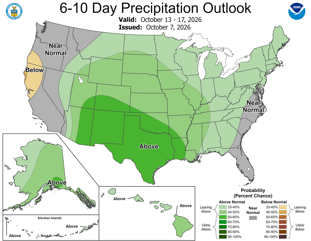
Heavy to excessive rainfall impacted significant parts of the Contiguous States this past week. Rain totals of 4 to over 8 inches were common across south-central and southeastern Georgia, northeastern Florida, the Florida Panhandle, parts of the immediate Gulf Coast, and a swath from central Texas through the middle Red River (South) Valley. This brought an abrupt end to a protracted spell of hot, dry weather across the southern Great Plains that had lasted through most of the summer. 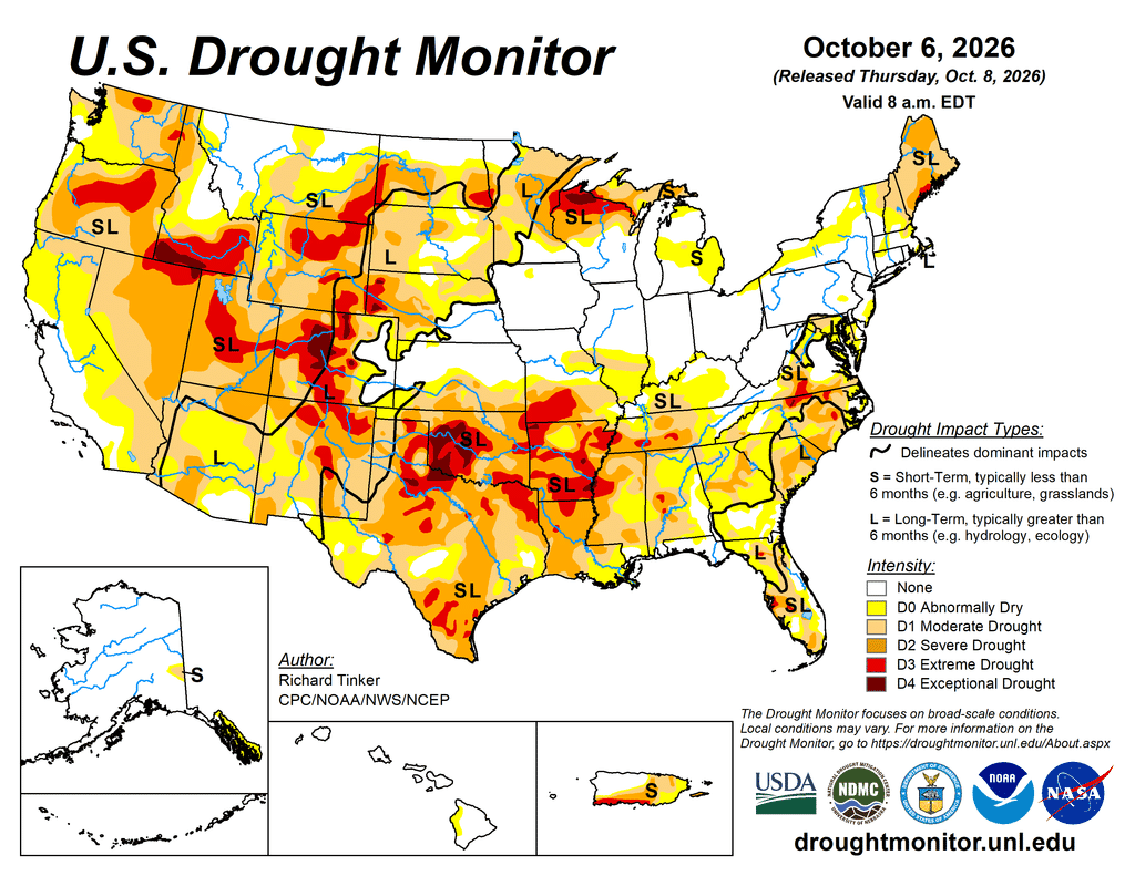
Dallas, TX, recorded 4 inches of rain from September 30 through the first week of October, including a daily total of 3.47 inches on October 1. Prior to that, Dallas recorded only 0.01 inch of rainfall from July 16 through September 29 (76 days), and a total of 2.27 inches going back to June 8. Elsewhere, a few broad areas recorded at least 2 inches for the week, including most of the Gulf Coast, southern Alabama, central and southern Georgia, the northern half of Florida, a large stripe through central and adjacent eastern Texas, central through southeastern Oklahoma, and in numerous patches from southeastern Colorado and much of Kansas through southeastern Nebraska, portions of Iowa, northern Missouri, northern Illinois, and the central to southern Great Lakes Region.
In some wetter areas across the central Plains and adjacent Front Range, impacts improved enough to justify 2-category improvements on the Drought Monitor. Meanwhile, several patches across northern Arkansas, southeastern Missouri, and the adjacent Lower Ohio Valley also received 2 or more inches of rain. Moderate totals exceeding 0.5 inch, with localized totals topping 2 inches, affected areas from the central High Plains and southern half of the Great Plains eastward and northeastward through much of the Mississippi and Lower Ohio Valleys, the central and southern Great Lakes, the Southeast, the Mid-Atlantic Region, and the St. Lawrence Valley. Meanwhile, light precipitation at best was observed through most of the Northeast, the Upper Ohio Valley, the far Upper Mississippi Valley, the northern Great Plains, and most areas from the High Plains to the Pacific Coast outside Kansas, Colorado, and northern New Mexico.

Many existing areas of drought that were impacted by the heavy precipitation experienced marked relief, but despite expansive areas receiving little or no measurable precipitation, drought intensification was limited in extent, largely due to the lower temperatures and the typical autumnal decline in human and environmental water demand.
The West
Moderate to heavy precipitation (0.5 to locally approaching 2.0 inches) fell early in the period across north-central and northeastern New Mexico, but conditions were quiet across the rest of the West Region. 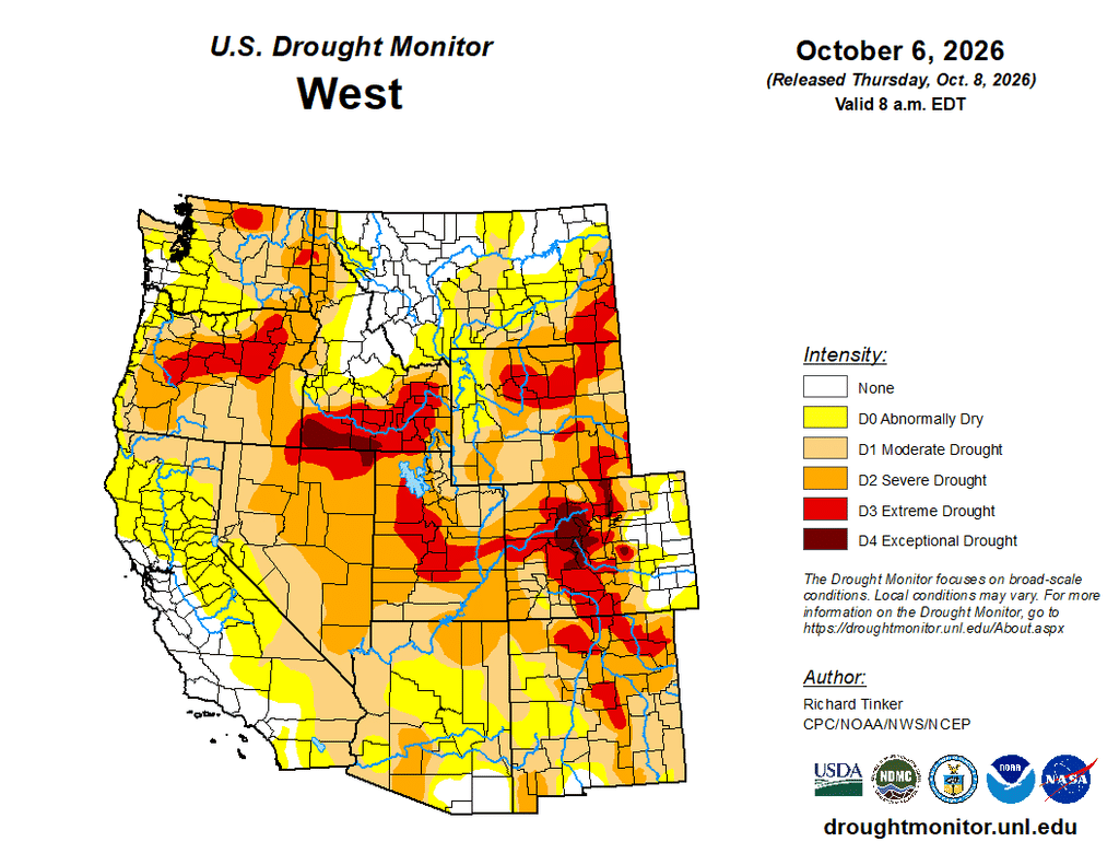
Scattered small areas reported a few tenths of an inch of precipitation last week, primarily in Montana and the lower Four Corners States, while most sites recorded no measurable amounts. But despite the predominantly dry week, fairly substantial improvement was noted as the environment responded to earlier above-normal to heavy precipitation.
Improvement was most common this week across New Mexico, Arizona, and Montana, with a few areas also noted in southeastern Idaho and Utah. Across almost all of Nevada, Idaho, and the three West Coast States, dryness and drought were essentially unchanged from the prior week.
The High Plains
Widespread heavy precipitation abetted robust improvement across eastern Colorado, central and western Kansas, and parts of southern Nebraska. Numerous locations reported 3 to more than 6 inches of rain, enough to support 2-category improvements in parts of southeastern Colorado and the western half of Kansas. 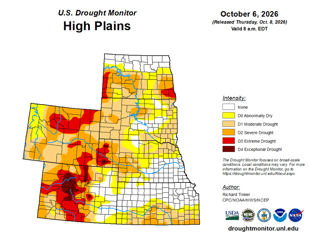
Precipitation amounts declined abruptly north of a line from central Colorado through northeastern Nebraska, and only a few tenths of an inch at best was observed beyond this delineation. Still, improvements appeared in parts of the central and northern Dakotas, where earlier precipitation may have been more beneficial than initially assessed. The only areas of deterioration were in northeastern Colorado and part of north-central Wyoming, which have consistently been north and/or west of the heaviest precipitation. Elsewhere, dryness and drought intensity did not change markedly from last week.
The South
A variable precipitation pattern was observed across Tennessee and the Lower Mississippi Valley last week, resulting in some areas of nominal improvement (scattered across eastern Tennessee, southeastern Louisiana, southern Mississippi, and northern and northwestern Arkansas) and other areas of somewhat increased moisture deficits and deterioration (scattered across central and western Tennessee, southern and eastern Arkansas, northern Mississippi, and central through southwestern Louisiana). 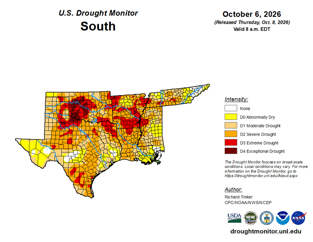
Farther west, across Texas and Oklahoma, broad areas recorded heavy to excessive precipitation, resulting in several sizeable areas of widespread improvement. Multiple inches of rain – for the second consecutive week in some areas – induced improvements across most of southeastern and Deep South Texas, and in a swath from central Texas through much of the Red River (South) Valley into central Oklahoma. Farther west, across the Big Bend and the Texas and Oklahoma Panhandles, light to moderate precipitation following last week’s excessive amounts led to widespread one-category improvements. Enough precipitation was observed to support 2-category improvements at a few locations in Deep South Texas, south-central Oklahoma, and the western Oklahoma Panhandle. A few patches in southwestern Texas and the northern interior missed the heavy precipitation that hit most locations over the past couple of weeks, resulting in scattered deterioration. Improvement was far more common across Texas and Oklahoma, however, than the mixed bag of changes noted farther east. — UNL Drought Monitor