Nationwide
This week, a powerful storm system crossed from the Great Plains into the Great Lakes, bringing widespread rain and thunderstorms to parts of the Midwest, and a historic blizzard to portions of the Upper Midwest, especially in northern Wisconsin and Michigan near Lake Superior.
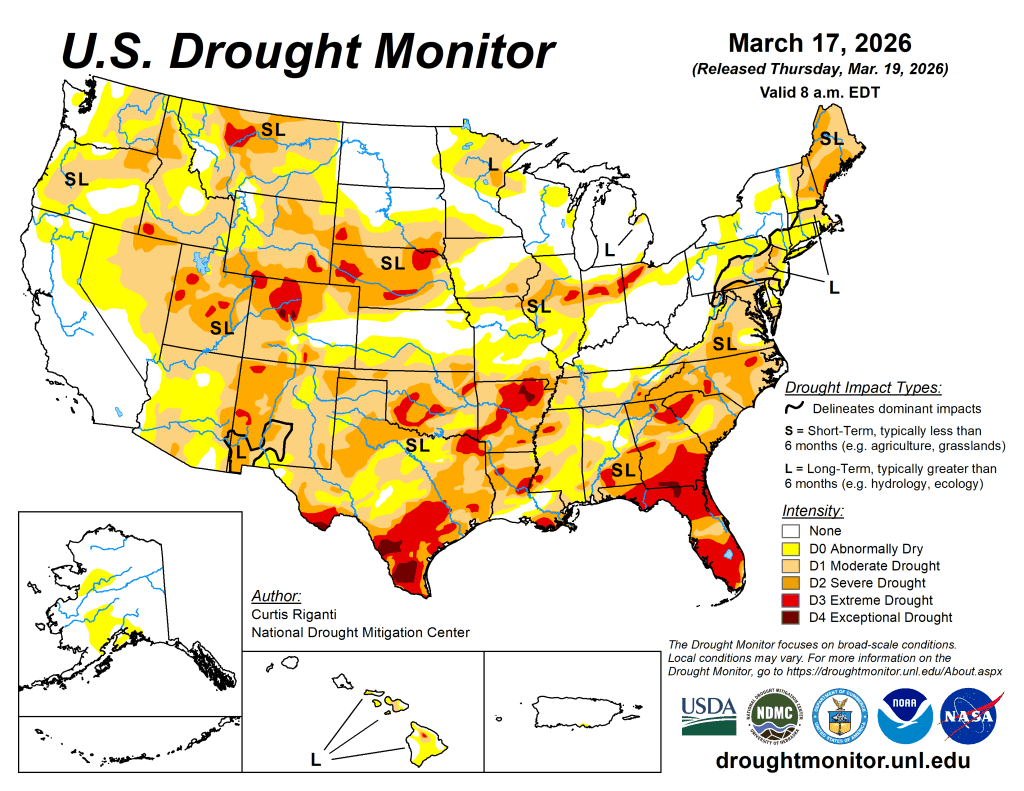
Total precipitation amounts exceeded 2 inches in a large area of the western Great Lakes, while lighter amounts, mostly 0.5-3 inches of precipitation, fell across parts of the southern and eastern Contiguous U.S. Improvements to ongoing drought and dryness occurred across large portions of the Midwest, parts of the lower Mississippi River Valley, and in the Northeast outside of northern New England. Heavy rain and, in some areas, mountain snow, fell across parts of the Northwest, locally improving drought conditions.
However, significant snow deficits still exist in many parts of the West, including the Pacific Northwest, limiting the longer-term benefits of the precipitation that fell. Much of the Southwest, and the central and southern Great Plains, missed out on precipitation, and instead dealt with a dry, warm and windy week. Precipitation deficits and a lack of snowpack in the mountains continued to worsen amid high evaporative demand, leading to widespread abnormal dryness and drought, especially in South Dakota and Nebraska, southwest Kansas, southern Colorado, New Mexico, Arizona, Nevada, and parts of Oregon that missed out on precipitation.
The West
Current drought conditions in the West continued to be headlined by snow drought this week. The Sangre de Cristo Mountains and portions of the San Juan Mountains in southern Colorado and northern New Mexico saw widespread worsening conditions this week.

Overall, dry and warm conditions worsened both precipitation deficits and snowpack conditions in these areas. Some snow-water monitoring sites in the region have seen near-full or full melting of the snowpack. Degradations to ongoing drought and dryness were also widespread in Arizona this week, where warmer-than-normal temperatures combined with dry weather to worsen short-term precipitation deficits, increase evaporative demand and support low streamflow levels.
High-elevation parts of Arizona that usually have snow on the ground in mid-March are also suffering from snow drought. This combination of drier- and warmer-than-normal weather and a snow drought may set the stage for worsening drought conditions in the coming weeks if the weather remains warm and dry. Warmer-than-normal and dry weather occurred this week in Nevada, worsening conditions in some areas, especially in the north, where impacts are being reported as a result of unusually warm and dry weather over the last several months and meager mountain snow. Due to locally heavy precipitation or lack thereof, a mix of small-scale improvements and degradations occurred in Oregon.
Amid the snow drought, localized degradations occurred in southwest Idaho, while heavier mountain snows improved snowpack in some mountain ranges in parts of western Montana, leading to localized improvements. The effectiveness of this locally renewed snowpack in improving soil moisture will be analyzed further in the weeks ahead.
The High Plains
In the southern half of the High Plains region, warmer-than-normal weather continued this week amid mainly dry and frequently windy conditions.
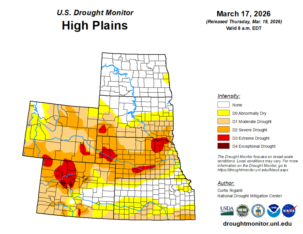
Degradation in drought conditions was widespread across Nebraska and the southern parts of South Dakota. A deadly wildfire in western Nebraska, the Morrill Fire, has burned a record amount of land for Nebraska wildfires. This fire, and others across Nebraska, occurred amid weather conditions favorable for fire growth and a background of worsening drought conditions. The Great Plains of southwest Kansas and southeast Colorado also saw worsening drought and abnormal dryness this week, as precipitation deficits continued to mount along with warmer-than-normal temperatures this winter and early spring. Large precipitation deficits and above-normal evaporative demand over the last several months led to extreme drought development in parts of the Black Hills in southwest South Dakota. Colder temperatures and some precipitation kept conditions unchanged (and mostly free of drought or abnormal dryness) in North Dakota and northern South Dakota.
The South
This week, parts of east Texas, Arkansas, Louisiana, Mississippi and Tennessee benefited from localized rains of at least 2 inches.
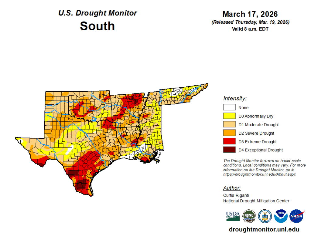
Elsewhere, deep south Texas, western Texas, and northern and western Oklahoma were mostly dry this week. Temperatures across the region were warmer than normal, with readings varying widely from a degree or two above normal to 9-12 degrees above normal. Soil moisture levels improved and precipitation shortfalls lessened in parts of east-central Texas, Louisiana and southeast Arkansas, leading to localized improvements to drought conditions in these areas. Despite heavier rains, a small area of extreme drought shifted northeast in southeast Tennessee due to very large precipitation deficits that continued this week. Growing short-term precipitation deficits led to the development of severe drought in a small area of northwest Tennessee. Heavy rain in Dallas improved local conditions. Warm, dry and windy conditions were the rule elsewhere in the southern Great Plains and deep south Texas, leading to localized degradations in central and northern Texas, deep south Texas, south-central and northwest Oklahoma, and the Oklahoma and Texas panhandles. — UNL Drought Monitor