Nationwide
Most precipitation across the contiguous United States fell in association with a large, impactful storm system that affected a broad area from the southernmost Rockies and the southern Plains eastward across a large part of the Mississippi and Ohio Valleys, the Southeast, and the Eastern Seaboard.

Winter storm warnings at one point blanketed nearly one million square miles, as a major winter storm delivered heavy and in some cases extreme snowfall, sleet, and freezing rain across much of the central and eastern United States. Impacts were widespread, with numerous locations across Pennsylvania, New York, and New England reporting 1 to 2 feet of snow or a mix of snow and sleet. Snow totals reached up to 17 inches in parts of Ohio and West Virginia, 15 inches across portions of Oklahoma, Missouri, Illinois, and Indiana, and roughly a foot in Arkansas, Kentucky, Maryland, and Delaware.
Farther south, intense sleet overlapped the southern edge of the heavy snow zone. Sleet accumulations peaked near 7 inches in parts of Arkansas, Louisiana, and North Carolina. Amounts near or slightly above 6 inches were reported at scattered locations across Oklahoma, Texas, Louisiana, Mississippi, Tennessee, and Maryland, with localized totals near 4 inches extending into Texas, the Carolinas, Virginia, and West Virginia.
Freezing rain added to the storm’s severity across portions of the South, in some areas following a transition from sleet. Ice accumulations of at least one inch were reported at isolated sites in Oklahoma, Louisiana, Mississippi, Alabama, and South Carolina. Elsewhere, ice thickness reached 0.7 to 0.8 inch in Texas, Kentucky, Tennessee, Georgia, Virginia, and West Virginia. These conditions led to widespread power outages and significant tree damage in many affected communities.
Liquid-equivalent precipitation totals exceeded one inch across parts of the southern Rockies and a broad swath from eastern Texas and western Arkansas eastward through the Tennessee and Ohio valleys, the Mid-Atlantic, and into parts of the Northeast. Several areas across the southern tier of the Lower 48 recorded more than 3 inches of precipitation, including central Texas, southern Louisiana, and a corridor stretching from northeastern Texas through northern Mississippi and northwestern Alabama. One localized area in southwestern Louisiana received as much as 10 inches.
Despite the storm’s scope, drought relief has been limited. In many northern regions, Arctic air has locked moisture in frozen form, delaying any meaningful improvement in drought conditions until temperatures rise and snow and ice melt.
The West
The southern fringe of the West Region was impacted by the western edge of the winter storm, resulting in over 1.5 inches of precipitation across a few patches from southeastern Arizona across southern New Mexico. Amounts exceeded 3 inches in parts of south-central New Mexico north of the Texas Big Bend. Precipitation fell predominantly as liquid in southeastern Arizona and was sufficient to bring improvements to that area.
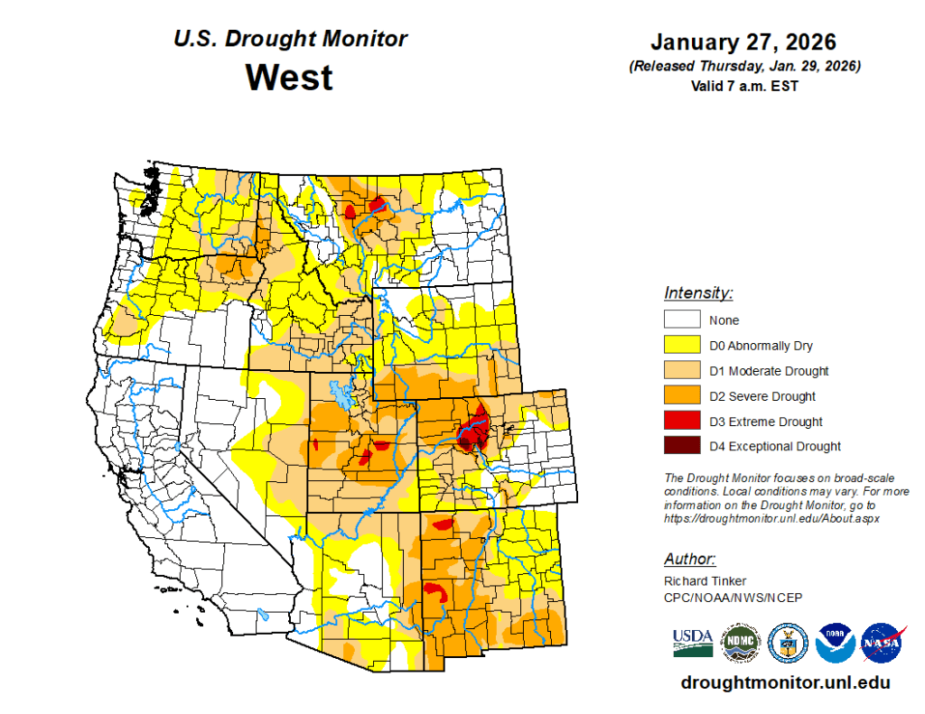
Farther east, although amounts were a little heavier, the precipitation was primarily in frozen form and remained unmelted. Therefore, only a few targeted improvements were introduced in a few small areas reporting the highest precipitation amounts (over 3 inches). Elsewhere, most of the Region received no measurable precipitation, with just a few tenths falling on some of the higher elevations of the Rockies. Still, there was no tangible deterioration across the Region during the dry week, in part because it followed a few weeks of relatively abundant precipitation. As a result, the Drought Monitor depiction was unchanged outside parts of the southern fringes of Arizona and New Mexico.
The High Plains
Most of the High Plains region was dry last week, with amounts of a few tenths to approaching one inch falling on much of central and eastern Kansas and on scattered higher elevations in Colorado and Wyoming.
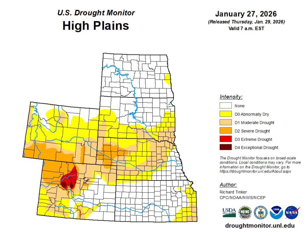
Otherwise, little or nothing fell. The region—outside the higher elevations—is climatologically cold and dry, so precipitation deficits increase very slowly, and demand is lower this time of year. Dryness and drought were essentially unchanged in most of the High Plains Region, with some scattered deterioration introduced in parts of western Colorado (to D1 or D2). Drought intensification was also introduced around the Black Hills and adjacent western South Dakota (to D0 or D1), where snowpack is deficient and slowly declining.
The South
One to several inches of precipitation was widespread across most of Tennessee, Mississippi, Louisiana, central and southern Arkansas, and eastern Texas.

Improvements were introduced in a number of areas, generally the areas that received the most precipitation, where much of the precipitation fell in liquid form, or where drought was already waning. To wit, some relatively broad improvements were introduced in Tennessee and, to a lesser extent Mississippi. Farther west, where subnormal precipitation dates back at least several months, improvements were more targeted to the areas receiving the heaviest precipitation, especially from central Louisiana northward, where precipitation remained unmelted.
Despite the precipitation accompanying the massive winter storm, Many areas in a band from northern Arkansas to the Louisiana Gulf Coast recorded 8 to 10 inches less than normal precipitation over the past 90 days, with a few spots in northeastern Arkansas and east-central Louisiana recording deficits approaching 12 inches during this period. Farther west, moderate to heavy precipitation was fairly widespread in eastern Texas, with lesser amounts toward the central part of the state. Southeastern Oklahoma reported amounts similar to eastern Texas (1.5 to locally 3.0 inches), but most areas farther northwest recorded less than an inch.
With much of the precipitation remaining locked up in frozen form, only a few surgical improvements were introduced in the areas with the most extreme totals in eastern Texas. A few inches of liquid-equivalent precipitation also fell farther southwest over south-central Texas. Temperatures were above freezing there at the end of the period, and the environment was beginning to respond to the moisture infusion, so somewhat more aggressive improvements were introduced there. — UNL Drought Monitor