Nationwide
Since the beginning of December 2025, drought expanded and intensified across the Lower Mississippi Valley and Southern Great Plains, which is typical during a La Niña winter.
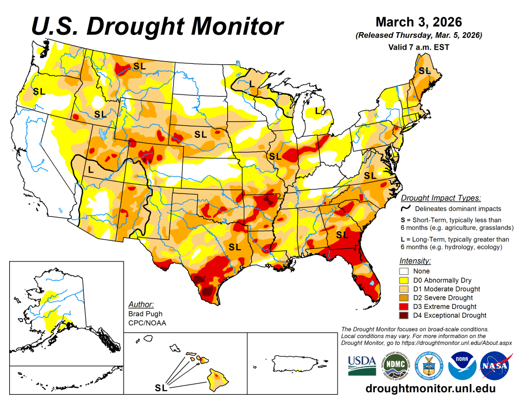
Much-needed precipitation at the end of February led to small improvements across parts of the Southeast and, at least briefly, stabilized the drought status in this region. Widespread severe-to-extreme drought is designated across much of the Carolinas, Georgia, southeastern Alabama, and Florida. A longer-term drought continues to affect the Mid-Atlantic and portions of the Northeast.
The unusually dry winter persisted across the Midwest through the end of February, with further degradation this past week. These worsening drought conditions extend west to the Central Great Plains, along with the Central to Northern Rockies. Below-normal snowpack remains a major concern for the West heading into the spring. Drought coverage decreased in Hawaii during the past few weeks, while Alaska and Puerto Rico remained drought-free.
The West
Water-year-to-date precipitation (October 1, 2025, to March 2, 2026) averaged below normal across the Great Basin, leading to a slight increase in moderate (D1) coverage across northeastern Nevada this past week.
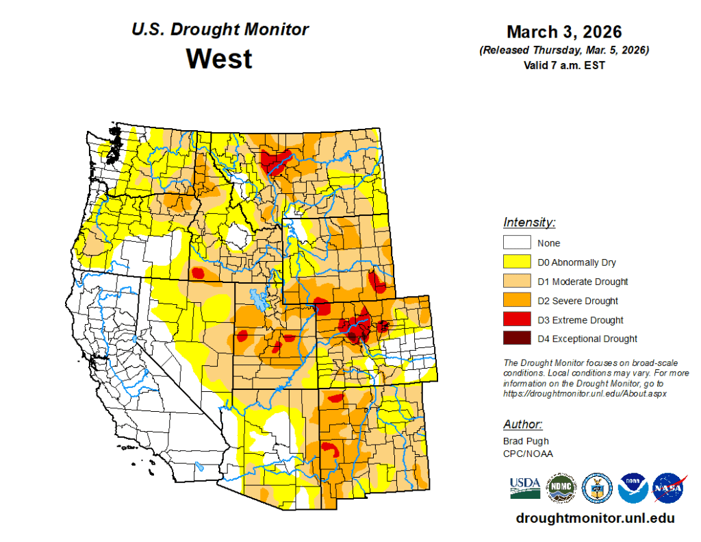
Following a drier- and warmer-than-normal February, a 1-category degradation was also made to parts of Montana. A 1-category degradation was also warranted for parts of Idaho, reflecting the below-normal precipitation and low snowpack this past winter. Even for areas of the West that have received above-normal precipitation since the beginning of October 1, such as the Northern Intermountain West and Northern Cascades of Washington, snow water equivalent (SWE) is running below normal.
The low snowpack throughout much of the West is a major concern heading into the spring. As of March 3, SWE is less than 50% of normal from the Cascades of the Pacific Northwest southward through the Great Basin and Four Corners region. Although California remains drought-free, SWE is 59% of normal statewide according to the California Department of Water Resources.
The High Plains
Although late winter is a relatively dry time of year across the Central Great Plains, unseasonably warm temperatures and strong winds this past month intensified drought across northeastern Colorado and Nebraska. 30-day temperatures averaged 6 to 10 degrees F above normal throughout the Great Plains.
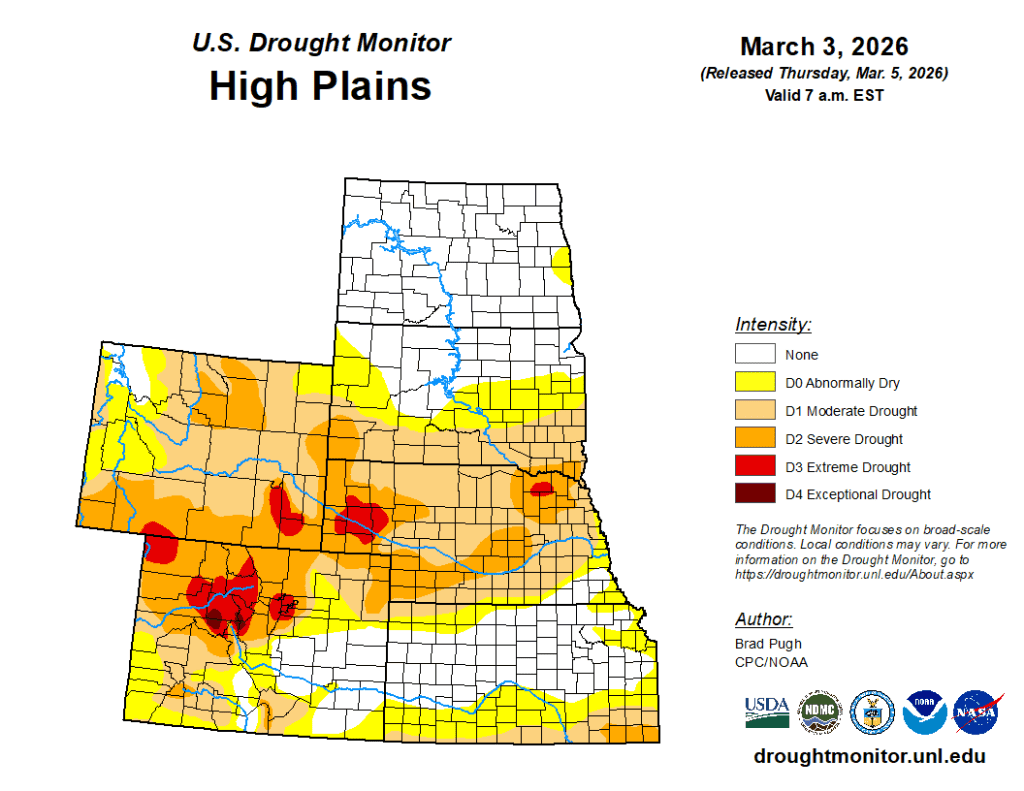
A 1-category degradation was made this past week to parts of Kansas and South Dakota. Widespread drought of varying intensity remains designated for much of Colorado and Wyoming. As of March 3, snow water equivalent is less than 70 percent of normal across the Central Rockies.
The South
Heavy rainfall (1 to 3 inches, locally more) resulted in a small 1-category improvement to parts of northeastern Tennessee. In the Lower Mississippi Valley and Southern Great Plains, drought continued to expand and intensify through the end of February and into the beginning of March. The major change this past week was a widespread 1-category degradation to Mississippi and also north-central Oklahoma.
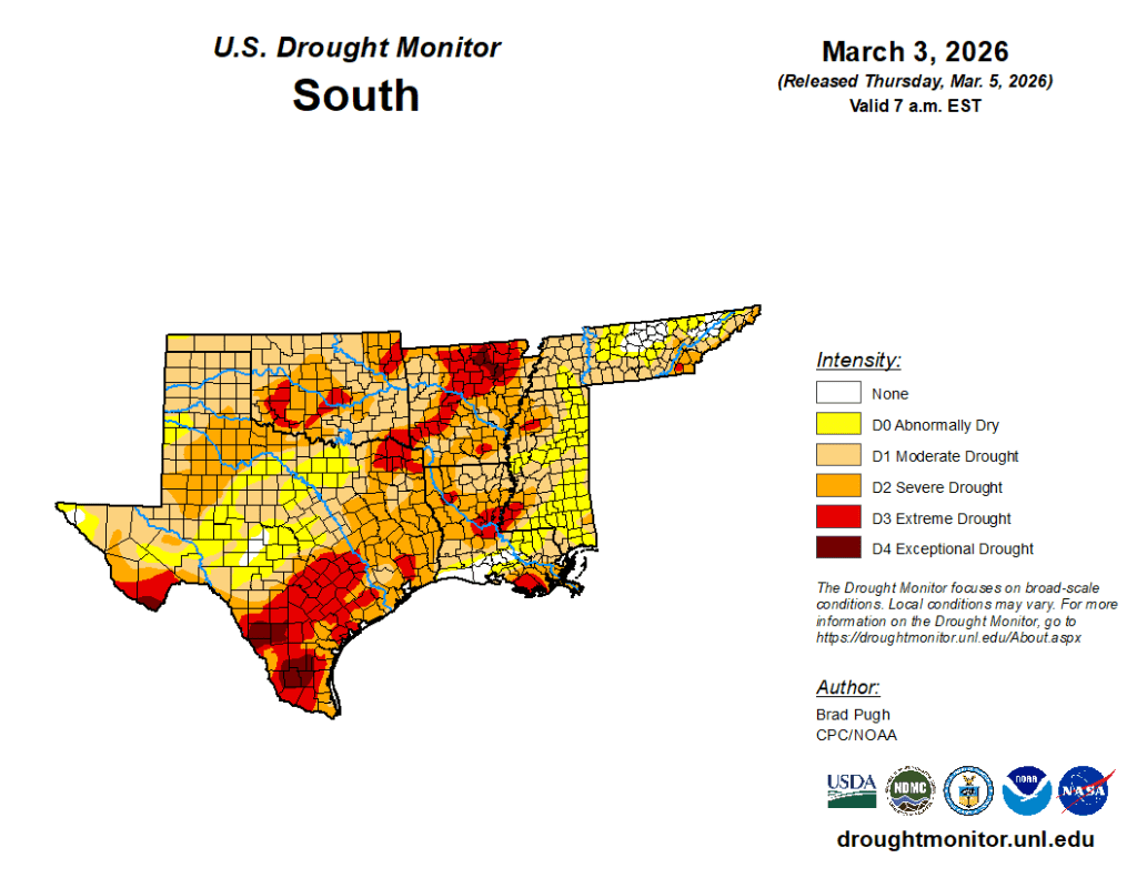
Since the beginning of December, precipitation has averaged less than 50 percent of normal across much of the Lower Mississippi Valley and Southern Great Plains. Impact reports from north-central Oklahoma include poor wheat conditions and surface water supply shortages. An expansion of moderate drought (D1) was also warranted for northeastern New Mexico. In addition to the drier-than-normal winter, 90-day temperatures have averaged 2 to 6 degrees above normal. The lack of winter precipitation combined with periods of unseasonably warm temperatures and enhanced winds led to an increasing coverage of severe (D2) to extreme (D3) drought from the Mississippi River west through Oklahoma and Texas. — UNL Drought Monitor