Nationwide
After a few warm, dry weeks, heavy precipitation returned to the West Coast States this past week; however, the heaviest amounts fell in California, which is almost completely free of drought.

At least 1.5 inches fell on a large part of the state, including much of the western tier, the higher elevations, and the northern Valleys. Much larger amounts fell on isolated higher-elevation and orographically favored locations, with a few spots recording amounts approaching 10 inches (liquid-equivalent). Several feet of snow have piled up in a few spots across the Sierra Nevada, but overall, the snowpack in this area remains significantly below normal. Other areas from northwestern California northward through the Cascades and points west also recorded significant amounts of precipitation, ranging from 0.5 to locally 3.0 inches. Similar amounts were more scattered across the rest of the interior West, with the largest totals confined to the highest elevations. As of early Tuesday, Feb 17, this precipitation has not significantly boosted snowpack in some areas with less than normal amounts, specifically much of the Cascades, south-central Idaho, Scattered locations across western Wyoming, much of west-central and southwestern Colorado, central sections of Utah and Nevada, and the southernmost Rockies.
Farther east, moderate precipitation was fairly widespread over approximately the southeastern quarter of the contiguous states, east of the High Plains and from the central Great Plains, lower Ohio Valley, and mid-Atlantic region southward. Heavier amounts fell on scattered areas across the east-central and southeastern Great Plains, parts of the adjacent lower Mississippi Valley, and a few narrow swaths across the western Florida Panhandle and parts of the northern Peninsula. To the north, scattered light amounts with isolated moderate totals were recorded in upstate New York and parts of New England. Other areas across the High Plains and the northeastern quarter of the contiguous states reported little or no precipitation.
Some areas of improvement were introduced based either on this past week’s precipitation or a re-assessment of the effects from earlier storms. Specifically, improvements were introduced in central Idaho, the southwestern High Plains, and parts of the Tennessee, lower Ohio, and middle Mississippi Valleys. There was more deterioration than improvement overall, however, including areas scattered across the Eastern Seaboard, lower Mississippi Valley, Deep South, Upper Midwest, northern High Plains, and far southern Texas.
The West
Heavy precipitation was fairly widespread across California, which is currently almost completely devoid of any degree of dryness or drought.

Elsewhere, widespread deterioration was introduced across central and eastern Montana, leaving most of the state entrenched in abnormal dryness to severe drought (D0 to D2), with an area of extreme drought in parts of north-central Montana. Elsewhere, only minor adjustments were made as light to moderate precipitation fell across much of the areas of dryness and drought – enough to preclude widespread deterioration, but not sufficient to justify much improvement. Only a few parts of central and south-central New Mexico were improved, primarily due to precipitation prior to last week. Severe to extreme drought (D2-D3) now extends across most of the western half of New Mexico, adjacent Arizona, central and northern Utah, parts of northern and southwestern Idaho, and parts of the Pacific Northwest east of the Cascades.
The High Plains
Moderate to locally heavy precipitation fell on part of eastern Kansas, and scattered light to moderate amounts fell on the rest of the southern tier of the Region.

Farther north, however, scant precipitation led to widespread degradation across a large proportion of Wyoming and central and eastern Montana, with more limited deterioration in parts of Nebraska and South Dakota. This resulted in moderate drought or worse across a swath of Nebraska and adjacent areas, extending westward through most of Wyoming and into the northern, central, and western sections of Colorado. Severe drought (D2) or worse is widespread across western Nebraska, the southern tier of Wyoming, and the northern and central parts of Colorado.
The South
Heavy precipitation (3 to locally 5 inches) dropped on a swath through central Arkansas, while 1.5 to locally 3.0 inches were recorded from the lower Red River (south) Valley through the central tier of Arkansas into much of western Tennessee.
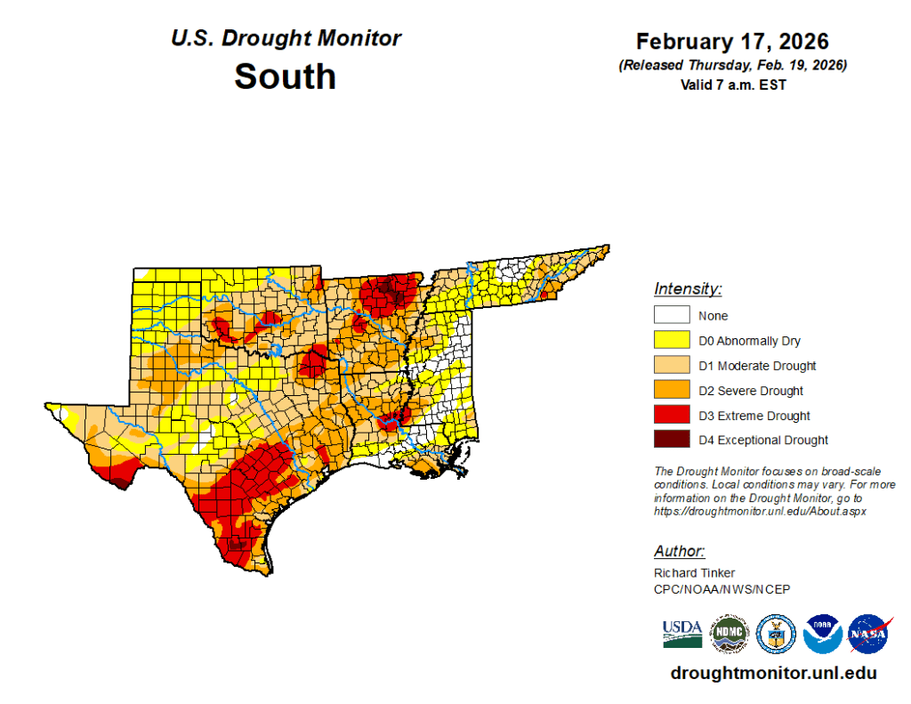
Moderate to locally heavy amounts were observed over much of the west side of the lower Mississippi Valley and portions of eastern Texas. Amounts of several tenths of an inch to locally around an inch were reported across a large part of central and north-central Texas, most of Oklahoma east of the Panhandle, much of Mississippi and western Alabama, and eastern sections of Tennessee. Little or no precipitation was reported across the Texas and Oklahoma Panhandles, western Texas, and Deep South Texas. This pattern supported improvement across the western half of Tennessee and smaller areas of Arkansas and northwestern Mississippi, along with scattered spots across southern Oklahoma. Deterioration was fairly common in areas that missed most of the week’s precipitation, primarily in the lower Mississippi Valley, the immediate ArkLaTex region, and Deep South Texas. The intensifying dryness in the latter area prompted the designation of exceptional drought (D4) in parts of Jim Hogg and Brooks Counties. D4 already existed in part of interior northeastern Arkansas and the southernmost reaches of the Texas Big Bend.
Meanwhile, extreme drought (D3) expanded to cover most of south-central and Deep South Texas, parts of east-central Louisiana and adjacent Mississippi, portions of southern Oklahoma and northeastern Texas, most of northeastern Arkansas, and a few smaller scattered areas in western Arkansas and northeastern Oklahoma. During the past 90 days, fewer than 2 inches of precipitation have fallen on western Oklahoma, the Texas Panhandle, and the southwestern tier of Texas from the Big Bend into much of Deep South Texas. — UNL Drought Monitor