Nationwide
This week’s U.S. Drought Monitor saw improvements and degradations across the country, largely shaped by uneven precipitation and widespread colder-than-normal temperatures.
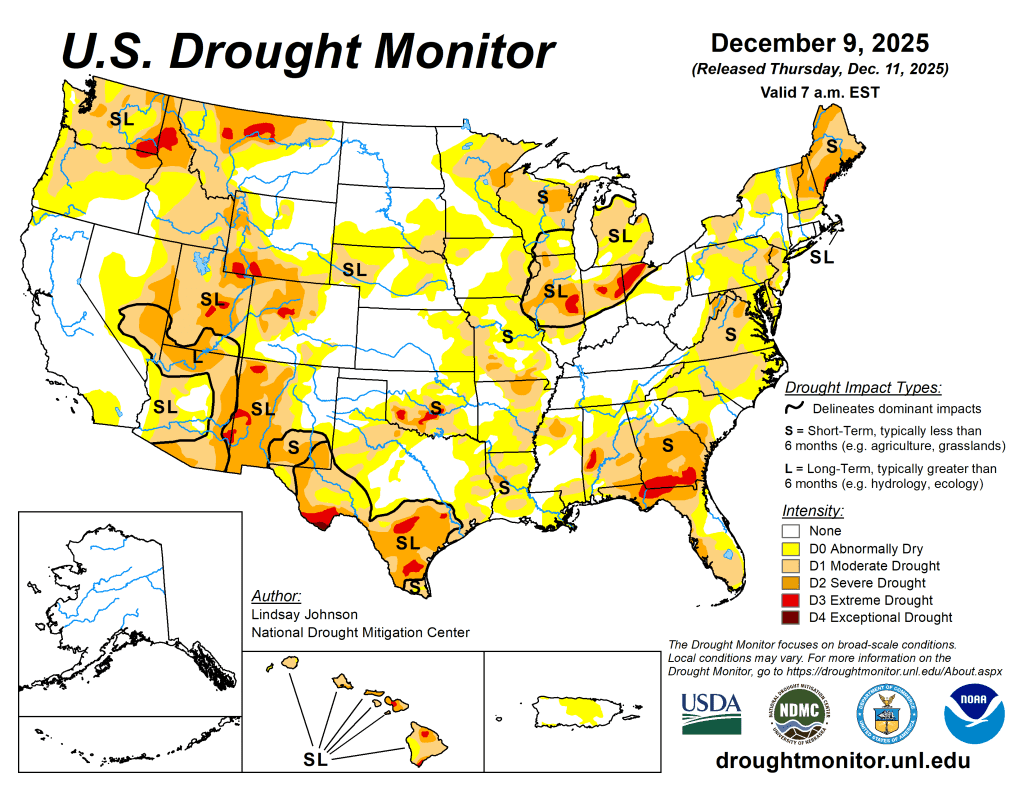
Much of the nation was colder than normal, with the sharpest departures in the Midwest and Northeast, where most of the week’s moisture fell as snow, offering limited short-term help for soils and streams. In the West, storm systems delivered substantial rain and mountain snow to the Pacific Northwest and northern Rockies, improving conditions in parts of Washington, northwest Oregon, western Montana and eastern Idaho.
However, areas that missed the heaviest precipitation—especially central and southern Oregon, central Idaho and southwestern Montana—saw drought expand as snowpack remained well below normal. Parts of the Southwest, including southeastern California and western Arizona, continued to improve as moisture from earlier storms worked through the hydrologic system, while east-central Nevada saw worsening drought due to very low snowpack and long-term precipitation deficits.
The central and southern Plains did not see any meaningful precipitation this week, leading to conditions remaining largely unchanged outside of localized areas. Short-term dryness worsened in southeastern Kansas and northeastern Oklahoma, where precipitation deficits continue to accumulate. In the east, several areas along the Gulf Coast and Southeast received 1-3 inches of rain, leading to widespread improvement in short-term dryness and drought in southern Alabama, southern Georgia, the Florida Panhandle and portions of the Carolinas. Despite moderate precipitation in southern Florida and parts of the interior Southeast, longer-term precipitation deficits led to dryness continuing to intensify. In the Midwest and Northeast, cold temperatures and predominantly frozen precipitation led to limited improvements and degradations in areas that missed precipitation.
The West
Out West, there was a mixture of improvements and degradations. Improvements were seen in the Southwest despite no precipitation this week. Prior weeks’ moisture has made its way into the hydrologic cycle, as seen in improving streamflows and soil moisture. Despite snowfall across the Rocky Mountains, many stations continue to report that the snow water equivalent remains below the 30th percentile.

Snowpack levels in the northern Rockies are improving, with many stations showing snowpack at 100% for this time of year, and this was further improved by 1-2 feet of snow falling across western Montana and eastern Idaho. This moisture led to areas of improvement in northwest Montana. Improvements were also seen along the Idaho-Wyoming border, where up to 2.5 feet of snow fell. Southwestern Montana and central Idaho, which are experiencing below-normal snowpack, missed out on snow and saw moderate drought (D1) expand across the border.
Across the Pacific Northwest, storms brought 6-8 inches of precipitation, with many stations in the Cascades reporting snowpack below 50% of normal. Areas in central Washington into northwest Oregon saw improvements as some short-term metrics were more aligned with moderate drought (D1) conditions rather than severe drought (D2). Central and southern Oregon, which missed out on the heaviest precipitation, saw the expansion of abnormal dryness (D0) and moderate drought (D1).
The High Plains
Conditions across the High Plains changed very little this week as much of the region received only light precipitation and remained colder than normal. The Dakotas saw little meaningful moisture, and Nebraska saw none, leaving drought conditions unchanged. In Kansas, a lack of precipitation combined with continued short-term dryness led to an expansion of abnormal dryness (D0) that stretched into northeastern Oklahoma.

In eastern Wyoming, dryness increased where precipitation was limited, resulting in some expansion of abnormal dryness. In eastern Colorado, light snowfall helped ease small pockets of abnormal dryness, though most areas saw little change.
The South
The South saw mostly improvements this week following a mixture of below-normal temperatures and heavy rainfall.
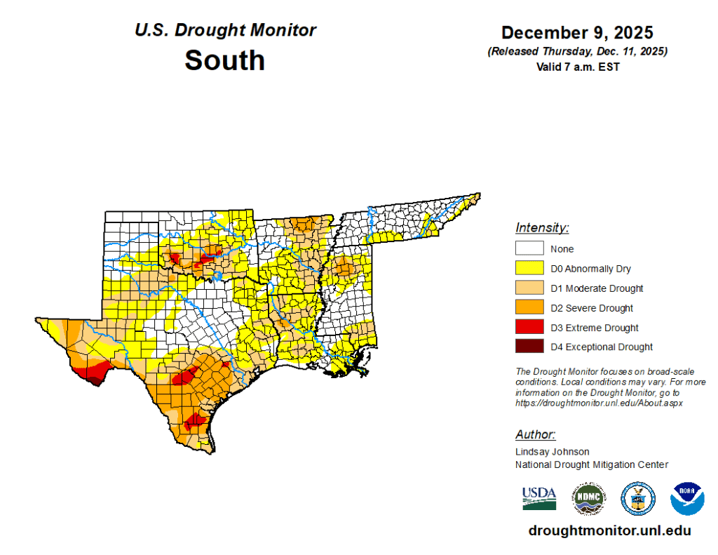
One-class improvements were seen from far eastern Texas to Mississippi, where 1.5-3 inches of rain fell, with parts of southern Louisiana recording 5-6 inches of rain. Areas of central Texas and the Panhandle that improved last week continued to see improvements in soil moisture and streamflows, leading to further improvements this week. Isolated degradation occurred in Texas’ southwestern Panhandle and in northeastern Oklahoma, as a lack of precipitation continues to stress soils and lead to lower streamflows. — UNL Drought Monitor