Nationwide
This past week’s drought summary featured generally worsening drought conditions from the Mississippi River Valley to the Southeast and Middle Atlantic states. 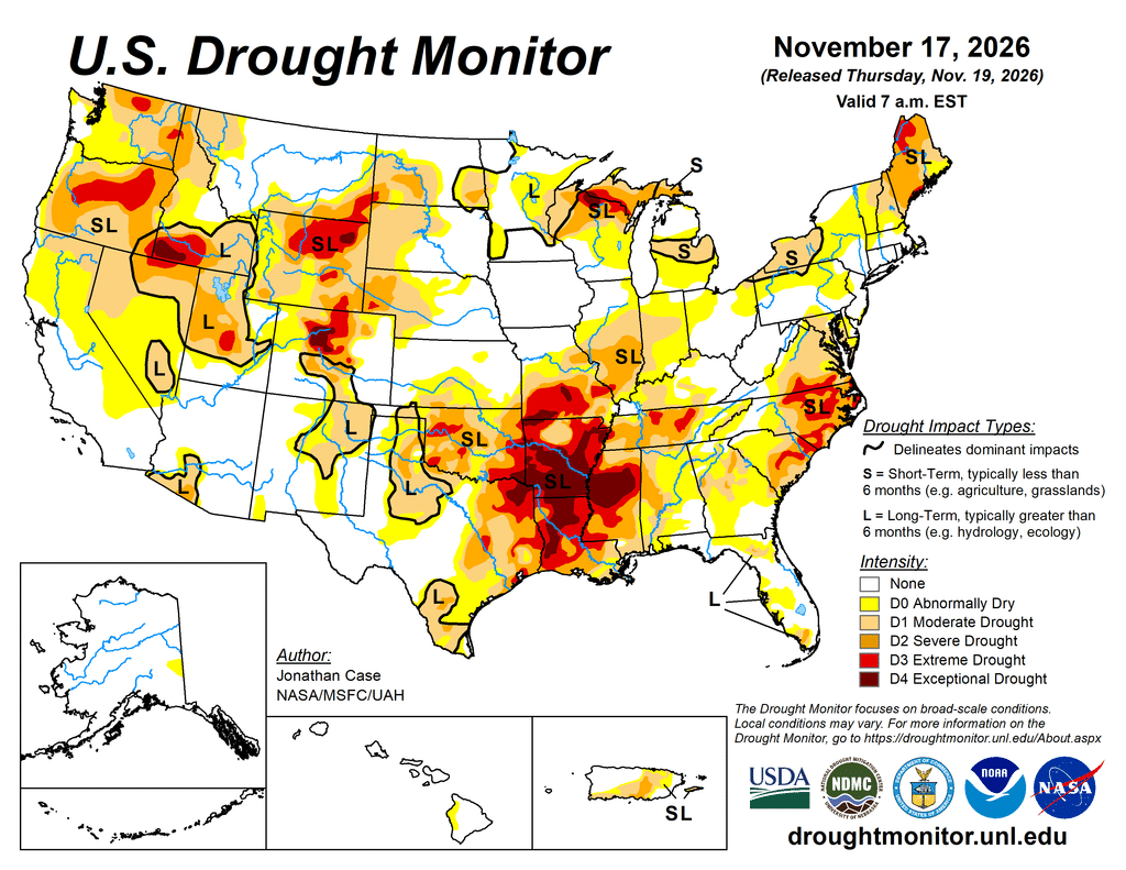
Meanwhile, more drought improvements were found from Southern California through the Four Corners region and into large portions of Texas and parts of Oklahoma. Additional targeted improvements occurred in the Olympic Peninsula of Washington State and parts of South Florida and the interior Northeast. Drought expansion also occurred in parts of the northern Rockies. Temperatures this past week were generally above average across the Northern Plains and Northern Rockies, while temperatures were below average and conditions were dry across the Southeastern U.S.
The West
A series of storm systems brought heavy precipitation to coastal Washington, Oregon, and Northwestern California. 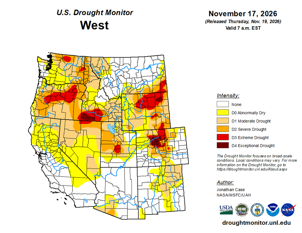
The Olympic Peninsula in Northwestern Washington experienced over 15 inches of rain in a typically wet location, which was sufficient to reduce drought categories. With many streams running at near all-time flows for this time of year, more widespread drought improvements were made across Southeastern California, Southeastern Nevada, Northern Arizona, Southern and Eastern Utah, and New Mexico.
The Southwestern reservoirs continued to experience more recharge this week, but at a slower rate than in previous weeks. The news was not all good in the West, however, as portions of Northwestern Montana and Northern Idaho saw the introduction of moderate drought due to temperatures 10 degrees or more above average combined with well-below-normal precipitation.
The High Plains
Only targeted changes in drought classification were made over the High Plains states this past week. 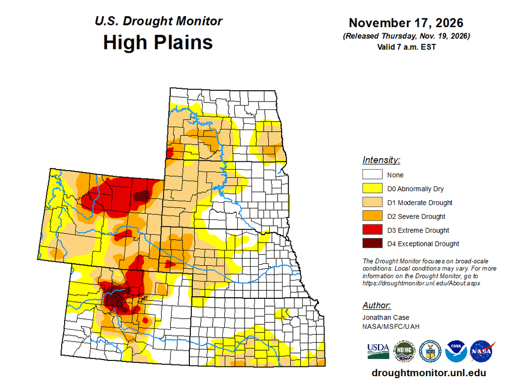
A small degradation occurred in the Northern Colorado Rockies with a couple of small degradations in Eastern Kansas. The most noteworthy degradations were made in Northern and Northeastern Wyoming, where well above-average temperatures combined with a lack of precipitation led to an expansion of extreme drought as well as an introduction of exceptional drought in northeastern Wyoming. Very poor long-term drought indicators, along with ground validation reports, suggested the need to introduce this exceptional drought area.
The South
Texas saw another round of very heavy rainfall that impacted central to southeastern parts of the state. Rainfall amounts up to three to four inches or more fell along the Gulf Coast between Corpus Christi and Houston Metro. As a result, more categorical improvements in drought occurred, helping alleviate severe to extreme drought conditions over Southeastern Texas. One to two inches of rain also fell over Central Oklahoma, helping to relieve drought conditions there as well.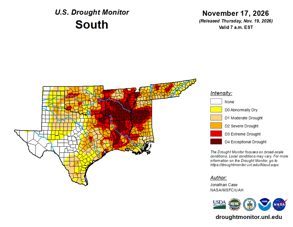
Unfortunately, the same cannot be said about Arkansas, Louisiana, and Mississippi, where exceptional drought conditions continue to spread. Mississippi saw a large expansion of exceptional drought across the central part of the state as the lack of rainfall continued to mount large precipitation deficits going back well over a year. Many parts of these three states require at least 20 to 30 inches of rain over a 3-month span to overcome current drought conditions. — UNL Drought Monitor