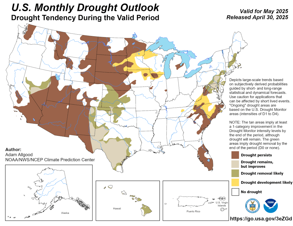
Nationwide
A blocking weather pattern that is common during the spring resulted in a couple of slow-moving low pressure systems from the end of April through the start of May.

These low pressure systems brought heavy precipitation (more than 2 inches) and drought improvement to the Northeast, Mid-Atlantic, and Southern Great Plains. The heavy precipitation across Oklahoma, western Texas, and eastern New Mexico was accompanied by cooler-than-normal temperatures.

Further to the north, drought expanded and intensified across portions of the Central to Northern Great Plains. Another area that experienced worsening drought was the Florida Peninsula. For the West, drought improvements were made to parts of Arizona, Utah, and western Montana.
The West
Recent widespread, heavy precipitation, along with consideration of multiple drought indicators such as Standardized Precipitation Index (SPI) at various time scales, soil moisture, 28-day average streamflows, and the NDMC drought blends, led to a 1-category improvement across eastern New Mexico.

Improvements were also warranted for parts of Arizona due to April precipitation averaging at or above normal. Minor improvements were justified for parts of western and southeastern Montana, but abnormal dryness (D0) and moderate drought (D1) expanded across parts of north-central Montana that missed out on another week of spring precipitation. No changes were made this week to California or Nevada as those areas enter a drier time of year. For the Pacific Northwest, long-term drought is limited to the northern Cascades region of Washington.
The High Plains
Mostly dry weather prevailed this past week (April 29 to May 5) across the Northern to Central Great Plains.
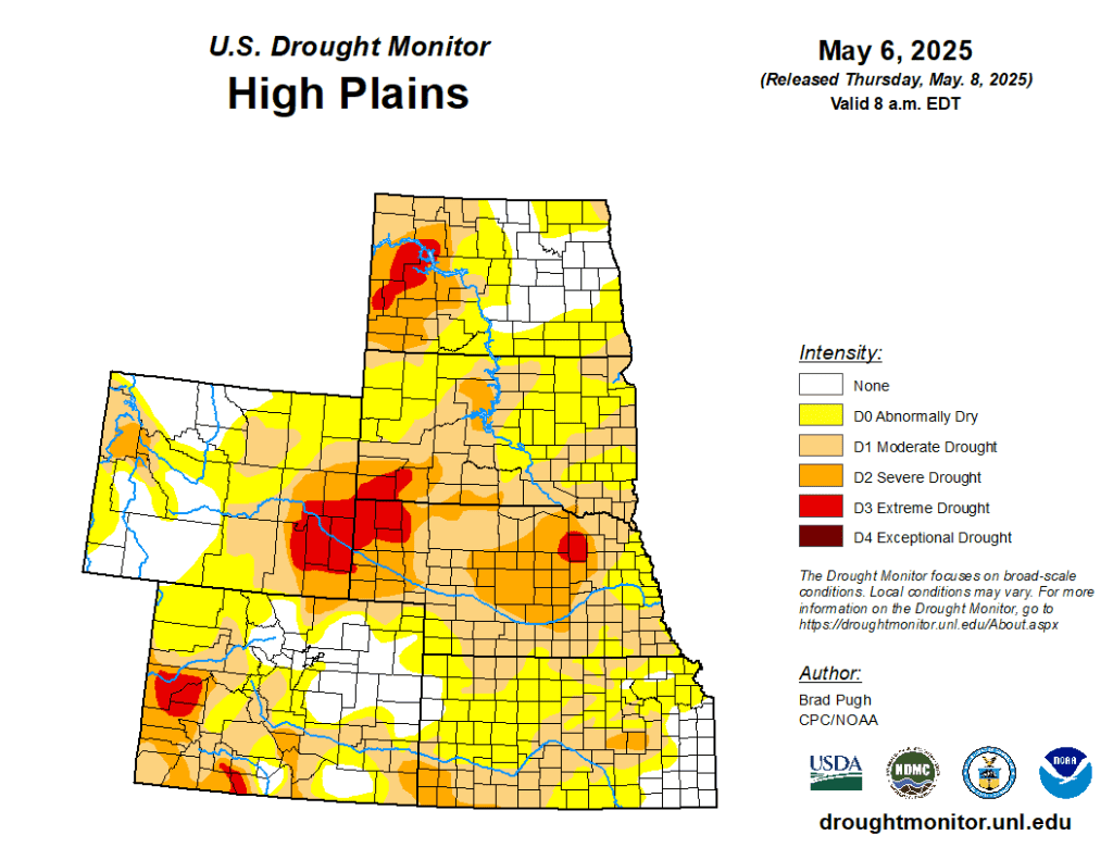
Based on multiple soil moisture indicators, extreme drought (D3) was expanded to include more of western North Dakota. This D3 expansion coincides with recent wildfires and dust storms. Soil moisture (below the 10th percentile), VegDri, and 60 to 90-day SPEI supported an expansion of severe drought (D2) across central Nebraska. D3 was added to parts of northeastern Nebraska based on VegDRI soil moisture below the 5th percentile and a longer-term extreme drought signal.
Further to the west, northeastern Wyoming and adjacent areas of western South Dakota experienced a broad 1-category improvement due to recent wetness and a positive recovery among multiple drought indicators. Improvements were also warranted for the upper Green River basin of western Wyoming. However, a drier-than-normal April resulted in a 1-category degradation in parts of southern Wyoming.
The South
Heavy precipitation (more than 2 inches) resulted in improvements to parts of Oklahoma and Texas. According to the Oklahoma Mesonet, 10 to 16 inches of precipitation was observed across central to southwestern Oklahoma during the past 30 days.

A 2-category improvement was warranted to the north of Midland based on a favorable response among soil moisture indicators. Any precipitation that occurred after 8 a.m. EDT on Tuesday, May 9th, will be considered in the next U.S. Drought Monitor release. This spring, a very tight gradient from excessive wetness across much of Oklahoma to extreme and exceptional drought closer to the Upper and Middle Rio Grande Valley has become established. Minor improvements were made to the small abnormal dryness areas depicted in parts of Mississippi and eastern Tennessee. — UNL Drought Monitor