Nationwide
It was a week with a lot of change noted in areas of dryness and drought across the U.S.

Heavy to locally excessive rainfall engendered broad areas of improvement in much of the Southeast, the lower Great Lakes Region, the central and northern Great Plains, and many locations across the High Plains and adjacent southern Rockies.
Meanwhile, continued subnormal precipitation and episodes of unusually hot weather, low humidity, and high winds led to large areas of deterioration in the central and northern Rockies.

Also, emerging short-term precipitation deficits led to the introduction of scattered areas of abnormal dryness (D0) over parts of the Middle and Lower Mississippi Valley, the Tennessee Valley, and near the western foothills of the western Appalachians. A few spots of deterioration were also introduced in western portions of the Southeast (where typical summer shower and thunderstorm activity has been less robust than usual) and Southwest (where subnormal monsoonal rains have been observed).
The West
Heavy precipitation prompted significant areas of improvement across the southeastern and northern sections of the West Region. Still, hot and dry weather has caused dryness and drought to intensify in central parts of the Region, across Utah, eastern Nevada, and northeastern Arizona (similar to the situation in western parts of Colorado and Wyoming).
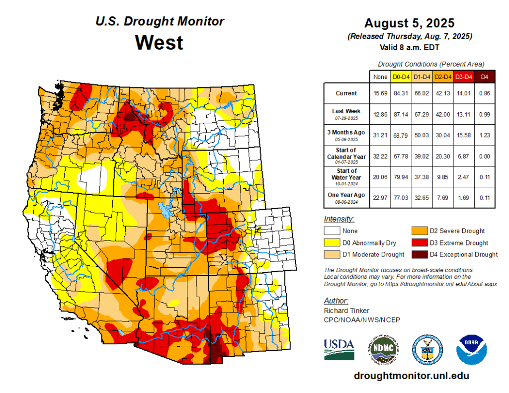
Reports of 2 or more inches of rain were fairly common across southeastern and north-central through northwestern Montana as well as northeastern New Mexico, with lesser amounts in other parts of these states. These rains brought 2-week totals to between 2 and 5 inches in much of New Mexico and Montana, with locally higher totals, especially in north-central Montana and northeastern New Mexico. This prompted broad improvements through both states, but even so, areas that missed most of the rain in these states remained entrenched in drought.
Exceptional drought (D4) persisted in parts of southwestern New Mexico, and extreme drought (D3) remained across north-central and southwestern parts of the state, along with a significant swath of west-central Montana. Moderate to severe drought still affected a large part of the remaining states despite improvements, and only the southeastern quarter of Montana and northeastern New Mexico have completely emerged from any designation of dryness or drought.
Further west, showery weather has occurred periodically over the past few weeks in central and eastern Oregon, resulting in a reduction in the coverage of dryness and drought in these areas. Across the central parts of the West Region, from eastern Nevada through Utah, rainfall has been far less generous, and drought has either persisted or deteriorated here. The entire region is currently experiencing at least moderate drought, with widespread D2 conditions across eastern and western Utah, as well as adjacent Nevada. Some expansion of extreme drought (D3) occurred in east-central and northeastern Utah, where conditions have been similar to those observed across western parts of Colorado and Wyoming. Elsewhere, no changes were observed, and broad areas of drought remained entrenched.
The High Plains
Rainfall varied in intensity across the High Plains Region, with abundant rainfall amounts falling on a large part of the Plains while lesser, subnormal totals were observed in the higher elevations farther west.
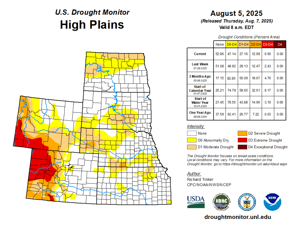
A similar pattern has been observed periodically for several weeks, resulting in significantly worse conditions in the western part of the region compared to farther east. A solid swath of moderate drought (D1) or worse covers most of southern and western Wyoming, as well as the western half of Colorado. Severe drought (D2) affects a large part of this region, and extreme drought (D3) is noted in a sizeable portion of west-central and northwestern Colorado. This represents a significant increase in the extent of D2 and D3 coverage compared to last week. In contrast, another wet week led to a continued reduction in the coverage of the abnormal dryness (D0) to locally severe drought (D2) over the Great Plains.
A broken pattern of heavy rainfall, with upwards of 3 inches reported in some areas, prevailed from northern Kansas through much of the Dakotas, although higher amounts were more common in certain regions than others. The improvements left severe drought confined to part of south-central Nebraska and adjacent Kansas, southwestern Nebraska, and a small area in south-central South Dakota. Moderate drought (D1) coverage also decreased, mainly across Nebraska and a few adjacent locations in the far eastern sections of Colorado and Wyoming.
The South
Outside southern and western Texas, there has been little to no dryness or drought observed across the South Region.

However, after a few relatively dry weeks, short-term precipitation shortfalls have developed in portions of Arkansas and Tennessee, resulting in the introduction of a few patches of abnormal dryness (D0) in areas experiencing significant 30-day rainfall shortages and near-to-below-normal 60-day totals. A much larger proportion of these two states reports 30-day precipitation deficits, but above-normal 60-day totals precluded more expansive D0 development this week.
Although the situation will need to be monitored going forward, the above-normal 60-day totals precluded more expansive D0 development this week. In Tennessee, some patches of abnormal dryness and isolated moderate drought (D0 and D1) were assessed last week. In the easternmost parts of the state, heavy rains engendered a bit of improvement, but the burgeoning dryness farther west allowed a few additional spots of moderate drought to develop. To the west, rainfall was sufficient to alleviate the fledgling area of abnormal dryness in southwestern Oklahoma, but a more widespread and intense drought continued to affect large parts of western and southern Texas. Moderate to heavy rainfall was observed over parts of the drought-affected region, leading to some improvement in the Big Bend and along the northern fringe of the region.
Substantial rainfall evaded areas farther to the south, however, allowing for some expansion of D0 and D1 conditions in the southernmost parts of the state. Since early May, rainfall totals have exceeded 3 inches in portions of south-central Texas and have approached 6 inches in parts of the Big Bend. Despite recent improvement in much of the state, however, a small patch of exceptional drought (D4) persisted in upper South Texas, and severe drought continued in adjacent areas as well as parts of the Rio Grande Valley and Big Bend. — UNL Drought Monitor