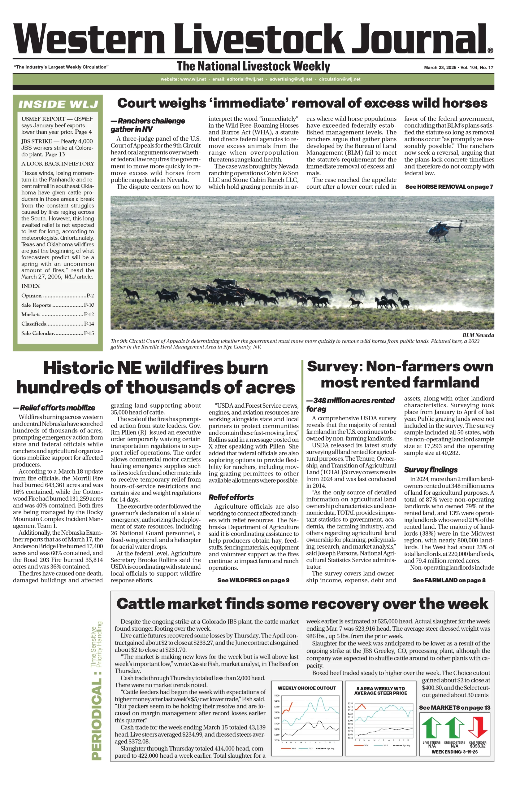
Nationwide
[inline_image file=”7bf1c3486108d930efbe1af4f2dfe524.jpg” caption=”20210601_usdm.jpg”]
Precipitation this past week was most active in the southern Plains and the Mid-Atlantic into the Northeast, helping to ease and improve drought in those regions. Some precipitation occurred in the South and portions of the Midwest, but the Southeast and Southwest remained dry through the week. For the time of year, temperatures were well below normal over most of the country, with departures of 9-12 degrees below normal in the Dakotas. Portions of the Southeast and Southwest did have pockets of above-normal temperatures, but even those areas were close to normal.
[inline_image file=”ad5eb731fdb50bd836c66c33d21bbb3b.png” caption=”Pasture May 30.PNG”]
The West
[inline_image file=”0bef1756d4884ef91b90dc800354efda.jpg” caption=”20210601_west_trd.jpg”]
The warmest temperatures in the region were over California and Nevada, where departures for the week were 3-6 degrees above normal. Most of the rest of the region was near normal for temperatures. Most of the West was dry for the week, but eastern New Mexico and western Montana received enough precipitation to improve their drought status. Impacts are building in the region with water cutback anticipated on Lake Mead. It is currently 37 percent full and fell below the critical 1,075-foot level triggering cutbacks to Arizona, Nevada, and Mexico.
[inline_image file=”d1b08687e392317964fae05864cf447f.jpg” caption=”20210601_az_trd.jpg”]
Abnormally dry and moderate drought conditions were improved over western Montana, while New Mexico had a large area of exceptional drought improvement due to recent rains. In Washington, conditions continue to dry out and abnormally dry and both moderate and severe drought conditions continued to expand.
The High Plains
[inline_image file=”80c7c5ab3b99de65ea25fd46cb263931.jpg” caption=”20210601_high_plains_trd.jpg”]
Temperatures were 4-6 degrees below normal, with even greater departures in the Dakotas, where some areas were 8-10 degrees below normal for the week. Much of eastern Colorado, southern Nebraska, Kansas and northwest South Dakota into southwest North Dakota received well over 150 percent of normal precipitation for the week. In Nebraska, abnormally dry conditions were improved over the north-central, southwest and extreme southeast portions of the state while moderate drought expanded over northeast Nebraska.
[inline_image file=”7a78536ef48bf685c5239836481e20f2.jpg” caption=”20210601_sd_trd.jpg”]
Severe drought was introduced over southeast South Dakota, with an expansion of moderate drought and abnormally dry conditions too. Southern Kansas and eastern Colorado had improvements to abnormally dry and moderate drought conditions while Wyoming had a mix of improvements and degradations to moderate and severe drought in the state.
The South
[inline_image file=”7174403b8467ceaa7d8941bbe75c32f6.jpg” caption=”20210601_south_trd.jpg”]
Much of the region had abundant precipitation during the week, with many areas recording over 200 percent of average rain. Along with the precipitation, cooler than normal temperatures were widespread, with most areas 3-6 degrees below normal for the week. The ongoing wet pattern allowed for continued improvements over most of Texas during the week, with most areas having a full reduction of the previous drought intensity level. Southeast Oklahoma had moderate drought and abnormally dry conditions removed, while portions of western Oklahoma also had unusually dry conditions improve. —UNL Drought Monitor
[inline_image file=”62eec481b6ccc891807d4e1a6e9f1cbc.png” caption=”610temp.new (3).gif”]
[inline_image file=”18d8afa5821501fbed238694abf04b05.png” caption=”610prcp.new (2).gif”]